Showing posts with label California. Show all posts

Fort Point National Historic Site, San Francisco

The Civil War-Era Fort under the Golden Gate Bridge

Did you know that there was a Civil War-era fort under the Golden Gate Bridge? I realize that at times I can be slow on the uptake, but I didn’t know about Fort Point until just a few years ago. And I grew up in California! How could I not notice? I’ve driven over the bridge several times in my life. The first time way back in high school. When I was in the army, I even flew a helicopter from Camp Roberts to the Presidio in San Francisco – didn’t notice it then. Finally, Fort Point came on the radar several years ago when I visited the Presidio as a tourist. Who knew? 

The history of the site goes back to the late 1700s. The Spanish were worried about encroachment into California by Russia and Great Britain. They built a fort on a cliff at the southern point of the narrowest entry to the bay. That would later be known as the “Golden Gate.” The fort, Castillo de San Joaquin, was completed in 1794, was made of adobe walls, and mounted from 9 to 13 cannons. When Mexico gained independence from Spain, the Mexican army moved to Sonoma and let the fort deteriorate.

At some point during the Spanish and Mexican eras, the cliff that the fort was located on was known as the Punta del Cantil Blanco (point of the white cliff) became known as Punta del Castillo (Castle Point). After the Mexican-American war and the United States gained control of California in 1848, the name was carried over as “Fort Point.” Soon the Gold Rush was in full swing, California became a state in 1850, and the United States now needed to protect the bay. A series of defensive fortifications were proposed that included Alcatraz Island, Fort Mason (located adjacent to Fisherman’s Wharf), and Fort Point.

The construction on Fort Point began in 1853. The first task was to knock down the cliff and build the fort near sea level. The idea was that guns placed in the first level of the fort could skip cannonballs along the ocean and hit ships at the waterline. Two hundred former gold miners were employed on the construction of the fort for eight years, finishing it in time to be garrisoned just before the start of the American Civil War in 1861. The fort is constructed with seven-foot-thick walls and three levels, or tiers, that built with a reinforcing arch. The fort could aim 126 guns at any ship passing through the narrow Golden Gate, although during the Civil War there were only 55.

Fort Point never fired a shot in anger. Time and technology made the fort obsolete. Navies of the world moved on to ships made of iron and steel. By the 1890s the smoothbore cannons at Fort Point were scrapped in favor of rifled, larger, coast artillery emplaced in concrete batteries at Fort Winfield Scott on the west side of the Presidio. Fort Point was used as a barracks for a time until it fell into disrepair. Recommendations to have the fort demolished in the 1920s were turned down. The fort was left standing even as the Golden Gate Bridge was built over it in the 1930s. After World War II, efforts were made to preserve the fort. In October of 1970, President Nixon declared Fort Point a National Historic Site.

Read complete histories of Fort Point at the National Park Service website, the Presidio San Francisco website, or on Wikipedia.

Fort Point is well worth the trip alone. But certainly, be sure to put it on your itinerary when you plan a trip to San Francisco. I enjoyed it more than exploring the coastal artillery batteries at the Presidio. Those coastal defenses built in the early twentieth century are common. I’ve also visited them at the mouth of the Columbia River and protecting the entrance to the Puget Sound. But on the west coast, Fort Point is the only one of its kind. There are no other Civil War-era forts, well preserved, on the west coast. I was fascinated by the architecture of the fort and the technology for the time that it was built. During the summer months there might be living historians or reenactor groups at the fort. Check with the NPS website. Oh, and bring a jacket. You know the old joke: “The coldest winter I ever spent was a summer in San Francisco.” 😎

Angels Camp and the California Goldrush

I was going through a bunch of pictures on my computer today. I used to urge everyone to scan and organize old, printed photos. I finally got that chore done myself a while ago. But I have come to realize that my computer is a lot like an old shoebox full of photos tossed in. Time to get organized. I’m working on getting that chore done. While eating the elephant one bite at a time, I came across some pictures taken in the city museum of the California Gold Rush town of Angels Camp that I thought I’d share.

A short few years ago we did a California Gold Rush trip that included Old Town Sacramento, Sutter’s Fort, and the Marshall Gold Discovery State Park. Part of that trip was driving down a major portion of California State Highway 49, sometimes called the “Gold Rush Highway.” You can start northeast of Sacramento in the town of Grass Valley and drive the Gold Rush Highway over 200 miles south, all the way to Oakhurst and Yosemite National Park. Along the way, you’ll pass multiple Gold Rush Towns with intriguing names like Coloma, Sonora, Jamestown, Chinese Camp, Placerville, and of course, Angels Camp.

The California Gold Rush had an initial phase that featured placer mining. Basically a technique of finding gold on the surface that had washed down over the centuries from a “lode” or major vein up higher in the Sierra Nevada mountains. Placer mining relied on a constant supply of water. Moreover, water is typically what brings the gold down the mountain. So you’ll find Gold Rush towns in conjunction with streams and creeks. Angels Camp is no different.

Today the city of Angels Camp is located at the intersection of Hwy 49 and Hwy 4, about an hour’s drive east of the Central Valley city of Stockton. Back in 1848, the water running down the mountain at that site was known as Carson’s Creek. Shortly after the discovery of gold that year, there was an estimated 4,000 would-be miners trying their luck in the area (a funny coincidence because that’s about what the population of Angels Camp is today). A man named Henry Angell, having come out to California from Rhode Island, set up a store on the banks of Carson Creek. Soon the town that grew around the store took his name.

Mark Twain stayed in Angels Camp for a while. It was there that he was inspired to write “The Celebrated Jumping Frog of Calaveras County.” That story made Twain a household name. The story becoming an American classic, it then inspired the annual jumping frog contest held each year during May at the nearby Calaveras County fairgrounds. Get a full history of Angels Camp from the Historic Hwy 49 website

What I enjoyed most about Angels Camp was the Angels Camp Museum, which is managed by the city. They have a great collection of wagons and carriages, mining equipment, even a period printing press. You can even try your hand at panning for gold. It is family-friendly and well worth the stop. Although I’m sure covid protocols are in place, the website reports that the museum is open. Well, you might want to wait for summer. But plan a Gold Rush themed California vacation and put Angels Camp on the itinerary.


The California State Railroad Museum

Memories from a pre-covid trip...

Last year I was teaching high school in California and we were sent home to conduct “distance learning” on March 13th and my old school is still at home trying to teach and learn via the Internet. That’s getting close to a whole year. Now, this post is not about the merits of distance learning or whether students should be in the classroom during a surge in the pandemic. When I decided to share some pictures of the California State Railroad Museum I was reminded that people in professions other than hospitality and travel are having a hard time during this crisis as well. There are a good number of museum workers at home too.

What I’m saying is that there is definitely a crisis for those working in museums and historic sites. Last summer there was an article in Forbes that said that the pandemic could close up to a third of all museums in the United States. Permanently. I was struck by this statistic when I checked in on the California State Railroad Museum’s website and found out that they had been closed completely since November 2020.

I hope that with the increasing availability of vaccines and through our own mitigation efforts, we will be able to travel to historic sites and museums once again. In the meantime, let me share some pictures from a pre-COVID-19 trip to Sacramento when we were able to walk through the museum and look at some trains up close and personal.

The California State Railroad Museum is in Old Town Sacramento, just north of where Interstate 5 and 80 intersect. It’s the historic waterfront of the Sacramento River. We did a blog post about our visit to Old Town Sacramento back before the pandemic. One of the main attractions is of course the railroad museum, but there are many shops, restaurants, and other attractions for non-train enthusiasts (is there such a thing?). In the summer months, you will also find historical reenactors encamped in the state park.

Since Sacramento was the western terminus for the First Transcontinental Railroad, the museum devotes an enjoyable and educational exhibit to this feat of engineering (that would be building a railroad through the Sierra Nevada mountains in the 1860s.) I especially enjoyed the exhibit on the heyday of passenger travel. If I did not make it clear, this museum is full of trains. So you will get to not only see the trains but also climb on them and go inside them. Another exhibit I liked was the homage to toy trains and the vast collection they have on display.

The California State Railroad Museum is a first-class, fun place to visit. Very kid-friendly. It rates a place on my “places I’d go to again” list. While it is currently closed for the pandemic (which has hit California especially hard over the holidays), you can still enjoy the museum online. Visit their website and maybe like their Facebook page, which is full of great pictures. You can still support museums with a cash donation or buy something from the museum store if they are available online (which the railroad museum is). 

Just remember that hard times don’t last. And if we never had it rough, we wouldn’t know when we had it good. But for now, enjoy some pictures of trains.

The Whalers Cabin at Point Lobos

Welcome to Monterey Bay!

We tried retirement, it just didn't stick. In reality, I just took the summer and fall off. That was long enough to get me back to work. Since January, Sheila and I have been living on Monterey Bay in the central California coast. I'm back to teaching alt ed high school, currently at a county juvenile hall. When you mention this area, most people probably think of beautiful views of a rocky coastline, Big Sur, or Cannery Row. But there is no doubt that there is a lot of history here in the Monterey - Salinas area too, especially compared to the rest of California. I wanted to share with you a hidden gem where you can get both scenic beauty and a little dose of history: Whalers Cove at Point Lobos State Natural Reserve.
Point Lobos SNR is just a short ten mile drive south on Pacific Coast Highway (Hwy 1) from the Monterey Bay Aquarium. Traveling south on Hwy 1, about a mile or two outside of Carmel you will make a right turn into the reserve. It costs ten dollars per car to get in, but totally worth it. Come early (the reserve opens to vehicles at 8 am), because this can be a popular place. I know I said it is a hidden gem, but that doesn't mean that the locals don't know about it. The ranger at the main gate can give you a map and directions, but it is a short drive to the parking lot at Whalers Cove. From there, you take a short walk back up the road to the Whalers Cabin museum that you drove by on your way in.

Take a break from the scenery and check out the long history of Point Lobos. The area has been occupied by non-native Americans since the 1850s. Until 1879, this spot was one of seven whaling stations along the California coast. Portuguese immigrants started shore-based whaling at this location. Crews would row out of the calmness of the small cove and past the breaking waves to hunt the grey whales that migrate up and down the California coast. You can still spot these giants as they pass by on their way south from Alaska to their breeding and calving lagoons in Baja during December through January. Or you might spot them as they return to their feeding grounds in the north, passing Monterey Bay from March through May. Of course there is more to the history of this particular spot. A community of Asian fishermen hunted abalone and canned the product here. There was a granite quarry here. The cove was used as the shipping point for a nearby coal mine. And troops trained here for specific missions during World War II. See artifacts and pictures of each of these periods in the small museum located in the Whalers Cabin.

Luckily, Point Lobos was never developed as any kind of residential property. Ownership eventually passed to the state of California, and the site was made into an ecological reserve in 1973. That also includes 775 acres of underwater reserve, the first designated in the United States. That's good for us normal folks because the real treat here is the views of plants and animals and rocky California coast. On the day that we went, we saw sea lions, an otter, and plenty of birds. The best way to see it all is to walk. Hiking trails honeycomb the shoreline around the point. There are three main parking areas, so you'd never have to walk more than a mile from your car. Or you can leave the car where it is and walk the whole point and probably not log more than five miles.

When you vacation to Monterey, take the opportunity to visit Point Lobos. It is very accessible and worth the time to stop. If I haven't sold you on visiting, then take a look at the Whalers Cove Live Stream, or take a virtual hike with Google street view. When you do come, bring a light jacket or sweatshirt as the coast here gets a marine layer at times that can be a bit chilly, especially if you just left the warmer interior.

The Mussel Slough Tragedy

Last year I was teaching at a high school in the Central Valley of California. As you know from reading this blog, I like to find the local history in the places we live and visit. Earlier this summer I told you about the spot in the San Joaquin Valley where Murrieta was killed. Continuing with the wild west history of California, I tracked down the location of the shootout at Mussel Slough.

About five miles to the northwest of Hanford, California, in Kings County you will find California Historical Landmark #245, that is titled Location of the Famous Mussel Slough Tragedy. It's located on a country road almost indistinguishable from all of the other farm roads in the San Joaquin Valley. Don't drive too fast or you'll miss it. I believe I drove by it at least four times before I finally recognized it for what it was. The text on the monument reads: 
Here on May 11, 1880, during a dispute over land titles between settlers and railroad, a fight broke out in which seven men - two deputy U.S. marshals and five ranchers lost their lives. The legal struggle over titles was finally settled by a compromise. Location: 5833 14th Ave, between Everett and Elder Aves, 1.5 miles SE of Hardwick.
It seems like a short description (in error) for what happened here. Especially since there are no original structures left, or even a tree that witnessed the event. Here's a summary of what happened.

In the nineteenth century the area was called the mussel slough region due to a slough off of the Kings River that backed into Tulare Lake. The lake and the slough are no longer present due to modern agriculture. The Southern Pacific Railroad was granted odd numbered lots of a square mile each as an incentive to build a line through the Central Valley of California. The line through this area was completed in 1872. Settlers had come into the area and homesteaded the even numbered lots and began to create improvements such as buildings, fencing, and irrigation ditches. This included hand-dug canals to bring water from the Kings River, more than two miles away for some.

In the meantime, the railroad put out brochures to sell the land they controlled. Farmers would be able to settle on the land for a few years, then gain title when a price was fixed. Brochures from the railroad advertised prices at $2.50 per acre and up. Of course the purchasers assumed that they were getting their land at that bargain price, and set about improving the land. When it came time to complete the transaction, the railroad insisted on valuing the land with improvements, inflating their asking price to twenty dollars an acre. After the railroad filed suit against settlers and won, the price inflated again up to $35 an acre. There was also an element of rancher versus farmer in that some cattlemen who had the wherewithal were stepping front of the farmers to purchase the improved land. 

With the stage now set, on May 11, 1880 a meeting of settlers was being held when false rumors where spread that U.S. marshals were conducting evictions. The settlers grabbed their guns and went to intercept them. The truth was that a railroad appraiser, two potential buyers from the cattlemen's side, and a U.S. marshal along for protection, were driving around in a carriage looking at properties. The two belligerent parties met at the site of the monument, the homestead of one Henry Brewer. While the marshal and a leader of the group of farmers stepped off to talk about resolving the situation peacefully, the bad blood between the farmers and the two from the cattlemen's side spilled over. No one knows who shot first or even what was said to start it. But in the end, the two cowboys and five farmers were dead.

No marshals were killed despite what the marker says. Five farmers were convicted of interfering with a marshal in the performance of his duties, each spending eight months in jail and paid a $300 fine. Although there was a high level of animosity toward the railroads, the people could not get the government to change the policy of providing land grants to railroads. In the end, the railroads reduced their asking price a token amount and most of the settlers stayed on their land and paid the asking price. At the time of the incident, the dead and wounded were brought to the shade of a large oak tree on the property that was referred to as the "Tragedy Oak." It blew down in the 1990s. A piece of the tree is reportedly put on display in front of a local elementary school. Ultimately the fight was lost to history, with the exception of some local interest and fans of old west history.

The Mussel Slough Tragedy took on a bit of mythology over the years and like so many wild west gunfights there are multiple versions of what actually happened. The three that I consulted, each with a little bit different take, are the Wikipedia article on the incident, "Garden in the Sun: A History of the San Joaquin Valley 1772-1939" by William Seacrest, and "Hanford" (Images of America Series by Arcadia Publishing by Robin Roberts.

Fort Humboldt State Historic Park

We decided to vacation in northern California a bit while on the way to Oregon this summer. While very scenic and awe inspiring (think big redwood trees), I was still able to fit in a little history tourism. I had just started the book on Ulysses Grant so we couldn't pass through Eureka without stopping off to visit Fort Humboldt, where Grant was stationed early in his army career.

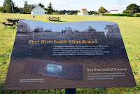
Fort Humboldt State Historic Park is the site of the fort that was occupied from 1853 to 1870. The fort was built overlooking
Humboldt Bay to provide protection to gold seekers and arriving settlers from the local Native Americans. Captain Ulysses Grant was stationed here for a few months in 1854. At its peak, the fort had 14 buildings arranged around a parade field. For the troops stationed here, the duty was dull and boring.

We visited the park in early June and the weather was still very cool compared to the Central Valley of California where we had just come from. Being the "morning people" that we are, we arrived just before they opened the gate. Actually, it's a good thing we had Google Maps giving us the step-by-step directions, as the signage directing you to the site was not obvious. The gates opened at eight o'clock. The visitors center and the two buildings of the fort that remain were not scheduled to open until nine. We spent an hour and a half walking around the park, starting with a display of logging machinery that is co-located with the fort. The park is certainly well tended, but not well visited by all appearances. We pretty much had the park to ourselves with the exception of a local walking her dog and some high school kids on bicycles that I'm pretty sure were ditching the last day or two of school.

The buildings at the fort are the original hospital and a reconstructed surgeon's quarters. The hospital building has some displays on the history of the fort, but unfortunately they were not open during the time we were there. I guess that the park is staffed by volunteers and they were having a late morning. It was disappointing, but the main thing to see when you visit a historic site is actually the location and the lay of the land. The fort is on a bluff and today the city of Eureka has grown around the bay that the fort overlooks. It is obvious that the fort is defensible with a small number of soldiers (I believe that less than 50 were typically at the fort), and the view allows for easily spotting arriving ships.

Probably the best part of visiting Fort Humboldt State Historic Park is knowing that you are walking on the same ground as U.S. Grant, George Crook, and other noteworthy soldiers from the Civil War period. You also gain a glimpse into what their living conditions were while serving in what was then still a far off place, well removed from the civilization in the East that these soldiers were used to.

Next stop in this little "Grant Pilgrimage" I've got going on will be
a visit to Fort Vancouver, another frontier outpost where Grant served before his civilian hiatus from the army.


Joaquin Murrieta and Cantua Creek

Sometimes I like to complain about California's relationship to their history, in that they don't have a relationship at all. I mean sure, you have some great Spanish Missions to visit, the best in my opinion is a state park. You also have a nod (provided by the NPS) to WWII history with the Rosie the Riveter National Historic Site. But the sites of many events receive no special standing. I believe that in most cases California land is just too valuable. Some places just get plowed under for a new housing development or, in this case, maybe an orchard. Or perhaps the site is just too remote. Even in California.

CA Historical Marker #344, about
nine miles from Coalinga.
For a year I commuted from Fresno across the San Joaquin Valley to Coalinga, California. I taught social studies at the local district's continuation high school there. Every day I would pass a historical marker and one day I stopped to read it. It said:
"14 miles [with a direction arrow] Arroyo De Cantua, Headquarters of notorious bandit Joaquin Murrieta. Killed here July 25, 1853 by posse of state rangers, led by Captain Harry Love. Terrorized mining camps and stage operations during his career. Historical Landmark No. 344. Department of Public Works - Division of Highways."
Joaquin Murrieta. Well, you know who he is. Murrieta is arguably the most famous of California outlaws. He terrorized the state during the Gold Rush with lots of mythology growing over the years. For some Californios he was a Robin Hood character, avenging the Hispanic community for the wrongs brought by the invasion of Anglo-Americans. It is said that the story of Joaquin Murrieta was the inspiration for the fictional character of Zorro. To the state of California he was a ruthless bandit. The new state government raised a party of "California Rangers" to hunt Murrieta down. They caught up to him and some of his associates, including "Three Fingered Jack" at Arroyo De Cantua, or Cantua Creek. (Check the location link at the bottom of this post for a Google map link.) This spot is on the far west side of the Central Valley, the closest city being Coalinga, a community of about eighteen thousand which was not founded until almost three decades after the incident.

Murrieta and Jack were both killed in the resulting shootout with Captain Harry Love and his California Rangers. Other members of the gang were captured. But to prove they had caught the famous outlaw and collect their reward, the rangers brought Murrieta's head and Jack's severed hand, pickled in a jar of alcohol. Of course there is the requisite conspiracy theory that they got the wrong man and Joaquin escaped to continue the good fight.

So why did they put the marker 14 miles away? The state Office of Historic Preservation doesn't say. On their website they say that the actual site is three large rocks located in the foothills southwest of Cantua Creek bridge. I admit I didn't go look for them. There are no roads to the site and the area is now private ranchland. However, I provide you a picture looking southwest from the bridge over the California Aqueduct in the area on the map marked as Cantua Creek. Yep, nothing but orchards out there. High lonesome. About twenty miles to Coalinga, and fifty miles back to Fresno.

Looking southwest from the Aqueduct at Cantua Creek.
My best guess is that when the marker was placed near the intersection of highways 33 and 198, that was the nearest they could get to the site where people might actually drive by and notice. The arroyo that was the site of the shootout might have been filled in, plowed over, and planted on by California's industrial agriculture machine. Or if it is in the foothills, it is being grazed on by cattle with no way to realistically get to the site. I don't know if I'm wrong headed in this, I mean, California agriculture land is pretty valuable. I just thought there would be more attention paid to California's most notorious outlaw.

.

Point Reyes and Drake's Bay

It is 308 steps down to the
lighthouse, and 308 back up!
One of our recent day trips was to Point Reyes National Seashore which is about an hour's drive north of San Francisco. We had never been to this area before and were not disappointed with the beautiful views there. Even though it was a weekday, there were plenty of people visiting. There is a nice visitor center there, but really, the star of the show here is nature. Plenty of walking and very little in the way of services. The highlight of the visit is a walk down hundreds of steps to the lighthouse. Unfortunately you have to walk back up!

So what does this trip have to do with history? Well, it's not about the lighthouse, although I do love them. If you look at a map of Point Reyes (Google Maps will do), you will see that the point wraps around a body of water named "Drakes Bay." Remember the story of Sir Francis Drake from elementary school? From 1577 to 1580, Drake and his ship, the Golden Hind, sailed into the Pacific to raid Spanish shipping, with the full
Waysides at the visitor center tell the
story of Drake's stay in California.
consent of Queen Elizabeth I. On June 17, 1579, Drake sailed into this bay on the northern California coast to make repairs to his ship before continuing across the Pacific ocean and eventually home. Drake and his men stayed for thirty-six days and by all available sources had pretty good relations with the local Miwok. Oh, yes, and he claimed the land for England. A brass plate that is believed to be made by the crew was later found in Marin County, along with other archaeological evidence to support journals kept by members of the crew.

The cliffs along this bay supposedly
reminded the English sailors of home.
On the day we visited, the only beach goers on this fairly remote beach was a number of elephant seals. So as not to disturb them, the humans didn't mingle. Regardless, it was a bit of a thrill for me to come to this place. First, there are very few places where you can go in California to see what the area might have looked like when Europeans first arrived. The remoteness of this seashore makes it one of the few. Also, Drake claimed this area for England nearly two hundred years before the Spanish would found a settlement on land that would become California and forty years before the English started colonies on the east coast.
The only visitors to the beach on the day
we visited were some elephant seals.
This makes Drake the first European to claim lands that would become any part of the United States.

Sutter’s Fort State Historic Park

One of my favorite historical fantasies includes the wonder of what certain places in California looked like before the modern world took over. I would love to be able to go back in time as an immigrant to California in the 1840s and be able to experience the sight of the Sacramento Valley before there was a city of Sacramento. Well, a trip to Sutter’s Fort State Historic Park doesn’t make that visualization any easier. The park is located in a quiet neighborhood on the corner of L Street and 28th, just a block or so west of Interstate 80. The fort used to be in the middle of rolling grassland in sight of the American River to the north and the Sacramento River to the west. Now it is surrounded by residential streets of Sacramento, less than two miles from the state capital.

Johann Augustus Sutter left his family in Switzerland and came to America in 1834 to escape debts and gain a fresh start. He was reportedly a huckster with a tendency to inflate his own resume, but by hook or crook he made it to California in 1839. When Sutter saw the land around the American River, he started making plans to build a farming and ranching empire. He sold his plan to the Mexican government of California and not only won Mexican citizenship in 1840, but also a land grant of 48,827 acres the following year. All he had to do was maintain order among the local Indians. He was also authorized to issue land grants and passports to American immigrants to California.

With the help of Native-American labor, Sutter built his fort with adobe walls that were two and half feet thick. The compound was reported to be 425 feet by 175 feet. Inside the fort there were carpenter and blacksmith shops, a gunsmith, a distillery, bakery, grist mill, and a blanket factory. Over the next several years, Sutter welcomed immigrants arriving over the California trail. Many new arrivals went to work for him. Eventually Sutter’s “New Helvetia” would encompass approximately 191,000 acres.

When James Marshall brought the gold nuggets to the fort in1848, Sutter initially tried to keep the discovery a secret. But once word got out, the flood of fortune seekers overwhelmed him and his holdings. Sutter lost his empire faster than he built
it. By the 1850s Sutter’s Fort was in ruins. The site was bought by the Native Sons of the Golden West and the fort was rebuilt in the 1890s. It then became part of the California State Park system in 1947.

Although the park was surrounded by the growth of Sacramento long ago, don’t let that give you the impression that this is not an enjoyable park to visit. And if I was going to recommend a starting point for a California Gold Rush trip, this would be the place, followed by a drive up to the Marshall Discovery site. For one thing, the drive up to Coloma would give you a feel for the expanse of land that was under Sutter’s control, if even for a brief time. The fort itself is a real treat to walk through. It is on par with the mission at La Purisma for the re-creation of the shops. There are plenty of artifacts in each to view as well as a period wagon. Check the park website for a schedule of events. If possible, visit on a day when one of the “living history” events is taking place. And while outside the fort there is a quiet modern neighborhood, inside it is easy to transport yourself back to the 1840s. Imagine what an oasis this settlement must have been after arduous months on the trail.