Defending Puget Sound: Fort Casey State Park

Spring finally sprung here in the Seattle area. We took an unusually nice day off weather-wise and drove to Fort Casey State Park on Whidbey Island, one of our favorite picnic spots. Along with Fort Worden and Fort Flagler state parks, Fort Casey is a former coast artillery position built around the turn of the twentieth century for the defense of Puget Sound. All three state parks are great for hiking, camping, or letting kids play on the old concrete batteries. Each one is around a two-and-a-half-hour drive from Seattle, including sometimes waiting for a ferry. But Fort Casey is my favorite.

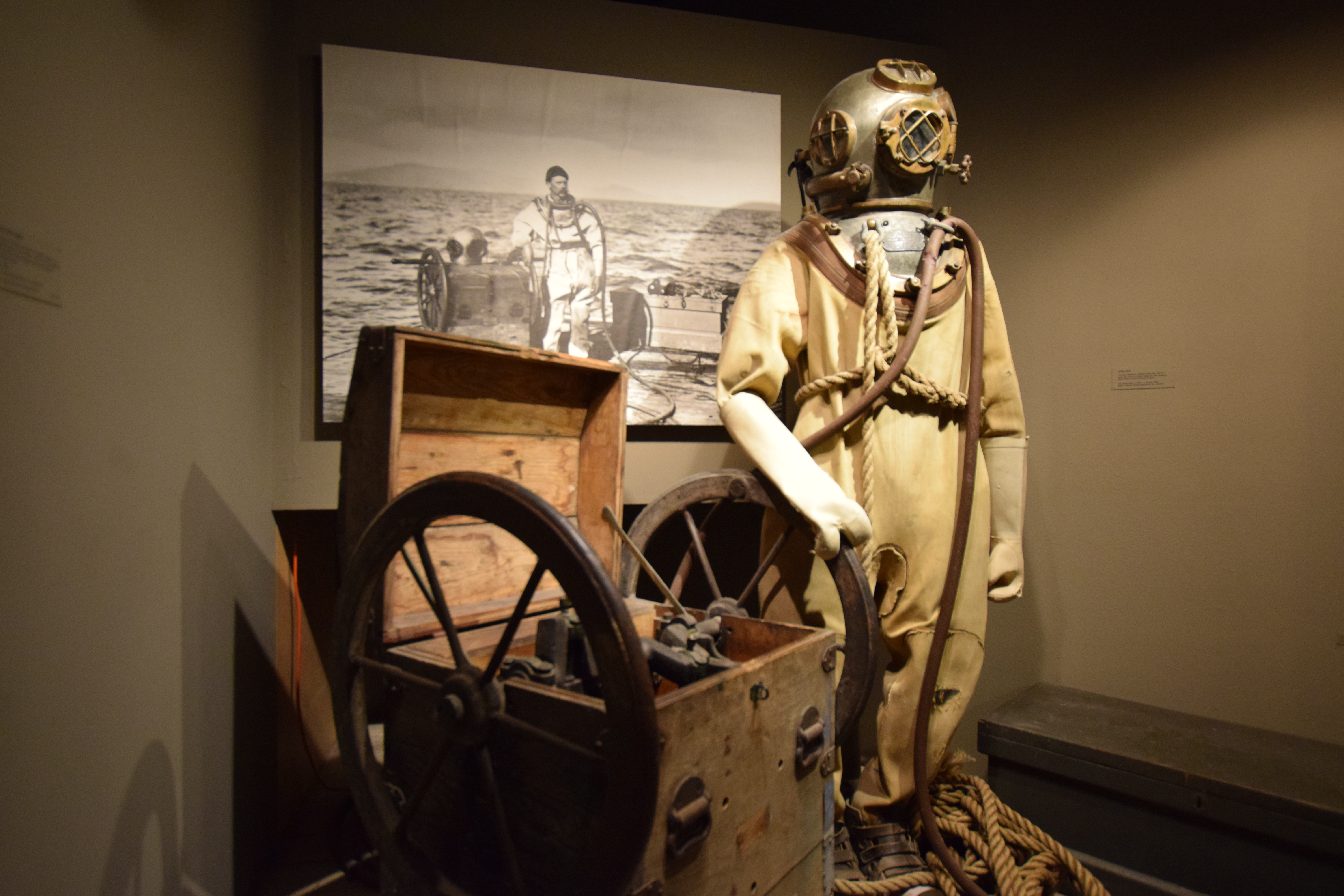
A new coat of paint and a restored
"disappearing gun"
Fort Casey has always been less crowded than the more noteworthy Fort Worden. Fort Worden, located at Port Townsend was the shooting location for the movie “An Officer and a Gentleman” with Richard Gere. Also, Port Townsend is a picturesque tourist destination. Not that it’s a bad thing, but it brings with it crowds and there is a bit of litter and graffiti on the walls of the batteries. Fort Casey is quiet and clean. As a matter of fact, on our visit we saw that the park is being restored to its original condition in that workers are applying a fresh coat of paint and are mounting two restored “disappearing guns.” This work should be complete by the end of May.

During the second half of the nineteenth century the United States was concerned about the defense of their new territories in the Pacific Northwest, particularly Puget Sound. There was a sense of urgency that came with increased tensions with Spain in the lead-up to the Spanish-American war. A survey of Puget Sound by the Corps of Engineers easily noted that Admiralty Inlet was a narrow gateway into the rest of Puget Sound. In fact, Admiralty Inlet is only about four miles wide. Construction was started in the late 1890s on all three forts, Casey, Worden, and Flagler, that would create a “triangle of fire” for any invading fleet.

It is only 4 miles across Admiralty Inlet
between Forts Worden and Casey
Fort Casey was activated in 1901. By 1907 there were 34 pieces of coastal artillery sitting 100 feet above sea level. Similar strength was located at the other two points of the triangle. This investment in defense didn’t last very long. The threat of invasion diminished. So much so that during the First World War, 13 of the guns were removed from Fort Casey and sent to France as heavy artillery and rail guns. Battleships got bigger, matching the forts for the size of guns. Also, the advent of the airplane that was able to bomb the forts necessitated removing the cannons and replacing them with anti-aircraft guns during the Second World War. 

Great views at Fort Casey
After WWII, Fort Casey stood vacant and fell into disrepair. The fort was officially deactivated in 1953 and was later transferred to the Washington State Parks. If you would like to know more about the defenses of Puget Sound, read this article on HistoryLink.org, or visit the Coastal Artillery Museum at Fort Worden. You also might take a look at the book, "The Pictorial History of Fort Casey" by Terry Buchanan.


Book R & R: Agent Sonya

This book “Recommendation and Review” is for “Agent Sonya” by Ben Macintyre.

I am a Cold War veteran, having spent three years patrolling the East German border back in the 1980s. Maybe that’s why I like spy stories so much. Fiction or nonfiction, it doesn’t matter. At least from a media standpoint, the Cold War made for some good spy stories. You had definitive bad guys (that would be the Soviets) versus us, the good guys. This book isn’t like that.

“Agent Sonya: Moscow’s Most Daring Wartime Spy” by Ben Macintyre is the true story of Ursula Kuczynski, also known as Ruth Werner, Ursula Beurton, Ursula Hamburger, or her code name: Sonya. She was born in Germany in 1907 and was a teenager and young adult during the political upheaval immediately following World War I. She became a devout, ideological communist, passionately opposed to the rise of fascism in her country. When her husband was offered a job in Shanghai, she went with him. There in China, she met other communists and was recruited into working for Soviet intelligence. Over her career worked in China, Poland, Switzerland, and Great Britain. Although Sonya didn’t “spy” firsthand, she did run agents in these locations and radio information back to Moscow.

I’ve read books by Ben Macintyre before, specifically Rogue Heroes and Agent Zigzag. So I knew the writing would be excellent and that this book, like the others mentioned, would be a true story that reads like fiction. What makes this book different from the usual spy story is that it is told from the perspective of Kuczynski. I gained an understanding of why a person would embrace Communism during the 1920s, especially if faced with a weak government (the Weimar Republic) and a threat of Fascism. As an aside, Ursula became disillusioned with the Soviet Union after the purges by Stalin in the 1930s, but she never lost her idealistic faith in communism. During the story of her career as a spy during the 30s and 40s, you of course sympathize with Ursula and are on the virtual edge of your seat during the times she was nearly caught.

SPOILER ALERT! If you don’t want to know the rest of the story, skip the next paragraph.

Why a book devoted to this one spy? One of her agents she ran in Great Britain was another German Jew, a talented physicist by the name of Klaus Fuchs. Fuchs had escaped from Hitler’s Germany and was sponsored into Great Britain. He was investigated and cleared to work on Britain’s atomic bomb project, despite being a devout communist. Once Fuchs realized what the project was about, he decided to share all the information about his work with the Soviet Union. Agent Sonya was his handler in Great Britain. When Great Britain’s nuclear bomb program was merged with the Manhattan Project (the United States nuclear bomb project), Fuchs was sent to work in the U.S. and passed off to a KGB handler in America. The information that Fuchs passed to the Soviets arguably gave them the bomb or certainly allowed them to develop their own five years earlier than expected. When Fuchs' treachery was found out, it would lead straight back to Ursula. In 1950 she escaped Great Britain and settled into retirement in East Germany, eventually writing a book about her own escapades.

So you have to ask: Did Agent Sonya help to start the Cold War or did she prevent World War III by helping to maintain a balance of power? Don’t try to answer that question without reading the book. I think it will change the way you look at that period of our history. It did mine. 

A Postscript to the Chapter on Anzio

You can stay in the house that was the 509th CP during the Battle of Anzio.
(click on any image for a larger version.)

509th CP during Anzio
For the most part, I’m not a big fan of social media. But sometimes it’s a bit of a miracle. Still, years after “The Boldest Plan is the Best: The Combat History of the 509th Parachute Infantry Battalion During WWII” was released, I am contacted by veterans, families, and others. It's a thrill and an honor. I must admit that it is especially exciting to be contacted by someone living in a country other than the United States where the Geronimos fought.

Map courtesy of
Mike Reuter
The other day I received a message from Diego Cancelli, an architect who lives in Aprilia, Italy, just a few miles outside of Anzio. Diego owns and operates Il casale di Giulia, a working farm and B & B. The stone farmhouse just happens to have been the 509th Battalion command post during the battle. He has pictures to prove it. Moreover, I have the image of a map that was provided by 509th veteran Mike Reuter that shows unit positions in the Anzio beachhead as of January 30, 1944. Sure enough, you can match up the unit symbol on the map with Google Maps. The 509th headquarters symbol is located on the Via Carano between Crocetta and Carano. That’s exactly where you’ll find Il casale di Giulia on Google Maps. You can even get a feel for the terrain by checking out Google Street View.

Il casale di Giulia before
rennovation.
Diego has located the hill that B company occupied forward of the MLR before they were overrun. The help that Diego required was being able to prove that the house his wife’s family owns and restored was one of the houses that were the object of “Raid Nibble.” Readers of “The Boldest Plan” know the details of the raid. The objective houses were simply referred to as House #5 and House #6 in the battalion’s war diary. No grid coordinates are offered so one must assume there is a map overlay. The problem we have, often repeated, is the lack of records in the archives for this unit. The Geronimos were attached to the 3rd Infantry Division, and during the battle; they had at different times the 7th Infantry Regiment and the 30th Infantry Regiment to their right. Perhaps there is a map overlay in the archives of these units?

After rennovation
There just were not that many houses in the area during the battle, so the odds are excellent that the house in question (that is now occupied by the family’s grandmother) is House #6 referred to in the 509th war diary narrative concerning Raid Nibble. Especially considering the war relics that have been found on both properties. Diego has been practicing some applied history and has amassed quite a collection as the included pictures show. He has found dog tags and returned them to the families of American soldiers. He has found several helmets both American and German. One of the German helmets was found along with the skeleton of the soldier who wore it; found during the restoration of House #6.
Aerial view showing B/509th
position on forward hill.

Diego shared quite a few pictures with me, and I’ve included some of them for you to see as well. The next time I’m in the archives at NARA or AHEC I plan to look in the records of the 3rd ID for that missing overlay. In the meantime, I’m planning a trip after covid to visit Anzio, Il casale di Giulia, and other sites where the Geronimos fought. Ever thought about it?


"House #6" today


Collection of military vehicles


Shells from WWII found
on the properties.


509th uniform in the 
reception area of the B&B


Dog tags found and returned
to their owners and families.


Cabinet full of battlefield
relics found on the property.


War relics found on the properties.


War relics found on the properties.


War relics found on the properties.


War relics found on the properties.


War relics found on the properties.


German helmets found around "House #6"

Book R & R: The Boy Who Followed His Father into Auschwitz

This book Recommendation and Review is for “The Boy who Followed His Father into Auschwitz” by Jeremy Dronfield.

By the cover design and title, I mistakenly at first thought this book was a work of fiction. So did my wife who first saw it on the shelf in our local bookstore. She read it; she was enthralled by it. Then she insisted that I read it. She is not a big reader of nonfiction history and rarely pushes me to read nonfiction (that’s because my nonfiction reading stack is always piled so high). So, I moved this read to the top of the list. Really glad I did.

This is a true Holocaust story that reads like fiction. In fact, the author started out a fiction writer but switched to narrative nonfiction. If you read a lot of books about World War II, you might know Jeremy Dronfield from his previous nonfiction work, “Beyond the Call.” At the time I’m writing this, “The Boy Who Followed His Father into Auschwitz” has 4.8 stars on 1853 reviews on Amazon. With numbers like that, it is no wonder it is a bestseller and I'm probably wasting your time telling you that the book reads like a novel. A “page-turner” as my dad would say.

The book is about the Kleinmann family of Vienna, Austria. There is the father, Gustav, a combat veteran of the First World War, his wife Tini, and their four children, Edith, Fritz, Herta, and Kurt. They are a Jewish family, but not overly devout, living in a Jewish neighborhood. They are part of the community; they have non-Jewish friends and neighbors. The story begins with the impending vote in Austria on Anschluss, the joining of Germanic peoples together under the Third Reich. The family lives through the arrival of the Nazis, the growing prejudice of their non-Jewish neighbors, and Krystallnacht. All this beginning in March of 1938, a year and a half before the beginning of World War II in Europe and over three and a half years before America entered the conflict.

Soon after, the Nazis begin to arrest Jewish adult males, initially as political prisoners. Gustav and his eldest son, Fritz, are caught up in this and sent to Dachau. Fritz was only sixteen. I had the opportunity to visit Dachau, a concentration camp outside of Munich, when I was stationed in Germany back in the 1980s. This connection allowed me to visualize the Kleinmanns in this evil and depressing place. Gustav and Fritz are transferred to other camps during the course of their years as slave laborers. While they are in captivity, Tini attempts to get her other children sponsored to immigrate to Great Britain and the United States. She is only partially successful. After years of starvation and beatings with no word from the other members of his family, Gustav is informed that he and hundreds of other prisoners will be sent to Auschwitz, the infamous Nazi concentration camp in Poland. Upon hearing this news, Fritz volunteers to go to Auschwitz with his father. Both believe this is a sentence of certain death, but they believe that it is better to be together than to die alone.

The book is based on a diary Gustav kept during his six years in concentration camps. Not only will you learn of the horrors of the concentration camp system, but also how difficult it was to flee Germany or an occupied country. Hint: countries like the United States and Great Britain limited the intake of refugees, and once the war was declared on and by these countries, even this avenue was cut off to the victims of the Nazi regime. This is an amazing story and through the experiences of this one family the reader gains a visceral understanding of the different ways that people suffered during the Holocaust.

I wish that every American would read this book. I spent three years in Germany, forty years after the war. I found the German people to be warm and friendly. I enjoyed my time there. Though I could never reconcile how the people I met there who were alive during that time could possibly allow the rise of fascism and the Holocaust to take place, much less enter a pathway to war that would eventually destroy their country. I worry that we have demonized the Nazis to such a level that we can’t learn anything from this period of history. I hope that is not the case. This is different than reading about fighting the war. This is about learning about the cause and effect of it. Please read two books. First, “The Nazi Seizure of Power” by William Sheridan Allen. In this book, you’ll learn how the Nazis took over Germany, not by Hitler from the top down, but on a grassroots level through local action by Nazi party members. The other is this book, “The Boy Who Followed His Father into Auschwitz” by Jeremy Dronfield. If you’ll make that investment of time, and it won’t be boring, then you’ll understand the what and the how. I doubt we’ll ever understand the why.


The Columbia River Maritime Museum

Learn About the Maritime History of the Pacific Northwest in Astoria, Oregon.

Astoria, Oregon, is located near the mouth of the Columbia River that creates the border between the states of Washington and Oregon. Astoria, the oldest city in Oregon, is an interesting and fun place to visit. Anyone who is on a Lewis and Clark pilgrimage is going to stay there of course. But there is a rich history about this town that goes way beyond the Corps of Discovery.

The Lewis and Clark Expedition spent the winter of 1805-06 at Fort Clatsop that they built just four miles to the southwest of modern-day Astoria. In 1811 fur trappers of the American Fur Company, owned by John Jacob Astor, established Fort Astoria where the city is today. Astoria is a deep-water port whose location on the Pacific coast made it a thriving resource town since then. Along with the fur industry, there is the timber industry and fish canneries for processing locally caught salmon. As you can imagine, not only the shipping of these commodities but the fishing industry as well creates a strong maritime history in Astoria. Oh, yes, and do not forget the Columbia bar.

Those of you not familiar with the area might be asking what the Columbia bar is exactly. Well, as the Columbia flows over 1200 miles all the way from Canada to the Pacific, it picks up sediment, as most rivers tend to do. As the waters of the Columbia hit the Pacific Ocean, it slows. When it does it drops the sediment creating what they call a “bar.” The Columbia Bar is an area about 3 miles wide and 6 miles long where the river enters the ocean. Because the bar creates shallows, the waters there tend to be rough and prone to a lot of unusual waves and currents. Plus, the sediment in the bar is always shifting around. That’s why large container ships need a river pilot to guide them into port. Moreover, combine the dangers of the bar with the naturally crappy weather of the Pacific Northwest and you’ve got some challenges. There are so many shipwrecks historically around this area (over 2,000 since 1792) that it has earned the nickname of the “Graveyard of the Pacific.”

This is where the Columbia River Maritime Museum comes in. This is a must-see when you visit Astoria. Most of the exhibits are indoors so don’t worry about the weather (oh, yeah, it rains a lot in Astoria). We made our trip pre-covid, but despite the pandemic, the museum is open with protocols. You will see exhibits on each of the industries that are a part of the history of this area. Particularly interesting to me is the information about the bar. Such a historically dangerous spot that had to be conquered (still true today) in order to exploit the resources of this region and on an individual level, earn a living. You’ll learn what a “bar pilot” does, and that there are only about 16 of these specialists working out of Astoria today. There is also a fine exhibit honoring the work of the United States Coast Guard in and around the Columbia River Bar.

When we visited Astoria, we stayed at the River Walk Inn, one of several hotels that provide a view of the marina from your room (nice!). From the hotel, you are able to catch a trolley that runs the length of the city with a stop at the Maritime Museum. The entry fee is a little pricey at $16 for adults, but that’s probably because I think all museums should be free. Regardless, the museum is worth it. Add it to your itinerary along with your pilgrimage to Fort Clatsop

For more information, visit the Columbia River Maritime Museum website.


Fort Point National Historic Site, San Francisco

The Civil War-Era Fort under the Golden Gate Bridge

Did you know that there was a Civil War-era fort under the Golden Gate Bridge? I realize that at times I can be slow on the uptake, but I didn’t know about Fort Point until just a few years ago. And I grew up in California! How could I not notice? I’ve driven over the bridge several times in my life. The first time way back in high school. When I was in the army, I even flew a helicopter from Camp Roberts to the Presidio in San Francisco – didn’t notice it then. Finally, Fort Point came on the radar several years ago when I visited the Presidio as a tourist. Who knew? 

The history of the site goes back to the late 1700s. The Spanish were worried about encroachment into California by Russia and Great Britain. They built a fort on a cliff at the southern point of the narrowest entry to the bay. That would later be known as the “Golden Gate.” The fort, Castillo de San Joaquin, was completed in 1794, was made of adobe walls, and mounted from 9 to 13 cannons. When Mexico gained independence from Spain, the Mexican army moved to Sonoma and let the fort deteriorate.

At some point during the Spanish and Mexican eras, the cliff that the fort was located on was known as the Punta del Cantil Blanco (point of the white cliff) became known as Punta del Castillo (Castle Point). After the Mexican-American war and the United States gained control of California in 1848, the name was carried over as “Fort Point.” Soon the Gold Rush was in full swing, California became a state in 1850, and the United States now needed to protect the bay. A series of defensive fortifications were proposed that included Alcatraz Island, Fort Mason (located adjacent to Fisherman’s Wharf), and Fort Point.

The construction on Fort Point began in 1853. The first task was to knock down the cliff and build the fort near sea level. The idea was that guns placed in the first level of the fort could skip cannonballs along the ocean and hit ships at the waterline. Two hundred former gold miners were employed on the construction of the fort for eight years, finishing it in time to be garrisoned just before the start of the American Civil War in 1861. The fort is constructed with seven-foot-thick walls and three levels, or tiers, that built with a reinforcing arch. The fort could aim 126 guns at any ship passing through the narrow Golden Gate, although during the Civil War there were only 55.

Fort Point never fired a shot in anger. Time and technology made the fort obsolete. Navies of the world moved on to ships made of iron and steel. By the 1890s the smoothbore cannons at Fort Point were scrapped in favor of rifled, larger, coast artillery emplaced in concrete batteries at Fort Winfield Scott on the west side of the Presidio. Fort Point was used as a barracks for a time until it fell into disrepair. Recommendations to have the fort demolished in the 1920s were turned down. The fort was left standing even as the Golden Gate Bridge was built over it in the 1930s. After World War II, efforts were made to preserve the fort. In October of 1970, President Nixon declared Fort Point a National Historic Site.

Read complete histories of Fort Point at the National Park Service website, the Presidio San Francisco website, or on Wikipedia.

Fort Point is well worth the trip alone. But certainly, be sure to put it on your itinerary when you plan a trip to San Francisco. I enjoyed it more than exploring the coastal artillery batteries at the Presidio. Those coastal defenses built in the early twentieth century are common. I’ve also visited them at the mouth of the Columbia River and protecting the entrance to the Puget Sound. But on the west coast, Fort Point is the only one of its kind. There are no other Civil War-era forts, well preserved, on the west coast. I was fascinated by the architecture of the fort and the technology for the time that it was built. During the summer months there might be living historians or reenactor groups at the fort. Check with the NPS website. Oh, and bring a jacket. You know the old joke: “The coldest winter I ever spent was a summer in San Francisco.” 😎

Angels Camp and the California Goldrush

I was going through a bunch of pictures on my computer today. I used to urge everyone to scan and organize old, printed photos. I finally got that chore done myself a while ago. But I have come to realize that my computer is a lot like an old shoebox full of photos tossed in. Time to get organized. I’m working on getting that chore done. While eating the elephant one bite at a time, I came across some pictures taken in the city museum of the California Gold Rush town of Angels Camp that I thought I’d share.

A short few years ago we did a California Gold Rush trip that included Old Town Sacramento, Sutter’s Fort, and the Marshall Gold Discovery State Park. Part of that trip was driving down a major portion of California State Highway 49, sometimes called the “Gold Rush Highway.” You can start northeast of Sacramento in the town of Grass Valley and drive the Gold Rush Highway over 200 miles south, all the way to Oakhurst and Yosemite National Park. Along the way, you’ll pass multiple Gold Rush Towns with intriguing names like Coloma, Sonora, Jamestown, Chinese Camp, Placerville, and of course, Angels Camp.

The California Gold Rush had an initial phase that featured placer mining. Basically a technique of finding gold on the surface that had washed down over the centuries from a “lode” or major vein up higher in the Sierra Nevada mountains. Placer mining relied on a constant supply of water. Moreover, water is typically what brings the gold down the mountain. So you’ll find Gold Rush towns in conjunction with streams and creeks. Angels Camp is no different.

Today the city of Angels Camp is located at the intersection of Hwy 49 and Hwy 4, about an hour’s drive east of the Central Valley city of Stockton. Back in 1848, the water running down the mountain at that site was known as Carson’s Creek. Shortly after the discovery of gold that year, there was an estimated 4,000 would-be miners trying their luck in the area (a funny coincidence because that’s about what the population of Angels Camp is today). A man named Henry Angell, having come out to California from Rhode Island, set up a store on the banks of Carson Creek. Soon the town that grew around the store took his name.

Mark Twain stayed in Angels Camp for a while. It was there that he was inspired to write “The Celebrated Jumping Frog of Calaveras County.” That story made Twain a household name. The story becoming an American classic, it then inspired the annual jumping frog contest held each year during May at the nearby Calaveras County fairgrounds. Get a full history of Angels Camp from the Historic Hwy 49 website

What I enjoyed most about Angels Camp was the Angels Camp Museum, which is managed by the city. They have a great collection of wagons and carriages, mining equipment, even a period printing press. You can even try your hand at panning for gold. It is family-friendly and well worth the stop. Although I’m sure covid protocols are in place, the website reports that the museum is open. Well, you might want to wait for summer. But plan a Gold Rush themed California vacation and put Angels Camp on the itinerary.


Snoqualmie Falls in a time of COVID-19

Okay, for all of you who have local roots in the Puget Sound, please do not judge me too harshly for this. But after living in western Washington for cumulatively a couple of decades, I had never visited Snoqualmie Falls. No excuses, other than most of the time we lived on the west side of the sound and just never made it a destination trip. So now that we are living on the east side of Lake Washington, we finally drove up for a look-see. Unfortunately, it was Martin Luther King, Jr. Day and quite a few other folks decided to join us. But more about that later.

Okay, for those of you unfamiliar with the Pacific Northwest, Snoqualmie Falls is a 268-foot waterfall on the Snoqualmie River, between the cities of Fall River and Snoqualmie, Washington. Perhaps it is easier to visualize if I just tell you that from downtown Seattle, get on eastbound Interstate 90 and drive for about fifty minutes and you will run right into it. There is free parking, a gift shop, a nice lodge, and a 1.4-mile round trip hiking path that runs from the upper viewing area down to a lower viewing platform. Of course, the real star is the falls themselves. They are beautiful year-round, but I gather that some dedicated individuals drive up there after a few days of heavy rain to get a view of the falls on steroids.


The falls have been a spiritual site for Native Americans for thousands of years. The Snoqualmie Tribe, a subgroup of the Coastal Salish people, would gather at the falls each year for trade. (See the official website for a complete history.) Anglo-American settlers moved into the area after the middle of the nineteenth century. Soon after came industrialization. The 1870s brought logging operations. The 1880s brought a town and a railroad. The 1890s brought a hydro-electric powerplant still operating today.

On the day we visited it was light overcast with no rain. A great weather day for January in Seattle. But do bring a rain jacket even if there is no rain forecast. The falls create their own mist. We arrived about 11 am, kind of late for us early risers, but still, we made it just as the parking lot was filling up. By 12:30, people were trawling for parking spaces. The view from the upper area where the Salish Lodge and the gift shop are located is great, so if you are not in the best of shape, there is no need to see the falls from the lower viewing area. There is a lower parking lot now open, so look for that on the map if you like. The hike down to the lower viewing platform is only a 0.7-mile walk. But it is a little steep and you’ll need your breath climbing the 250 feet back up to the upper parking lot.

We are still working with COVID-19 restrictions and I was happy to see that although viewing the falls is an outdoor activity, a vast majority of people were wearing their masks and doing their best to stay socially distanced. That social distancing was easily accomplished up top and on the trail down. But as you get to the bottom, the trail narrows to a boardwalk that goes past the old 1911 powerplant building and out to a viewing platform. Unfortunately, when we got down there, it was busy. A crowd that could stay distanced in the upper viewing area could not on the sidewalk-width of the boardwalk. Folks were patient and queued up nose-to-back along the boardwalk waiting for their turn to go out onto the viewing platform. But that’s not the point.


Everyone was cooperating and waiting their turn. That was great. But there was no guide or park ranger (this is not a state or national park) to keep people distanced. And hardly anyone would have seen this situation as dangerous while we are fighting a pandemic. We decided it was not worth it and left the line after about a minute when we realized that it could very well be a “super spreader.” I am writing that tongue-in-cheek, but it is true. Sheila and I both have had the “Rona” virus as some of my students call it. Trust me. You do not want it. And we didn’t want to get it again.

Enjoy the pictures and videos. Stop by and see Snoqualmie Falls when you are driving from Spokane to Seattle. It is worth the stop. Look at the Falls and think of a much longer history that you are seeing. And double-down on those protocols: mask, wash hands, stay distanced. The only way to get through the pandemic is with a little dose of discipline and good judgment.