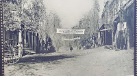
Angels Camp and the California Goldrush

I was going through a bunch of pictures on my computer today. I used to urge everyone to scan and organize old, printed photos. I finally got that chore done myself a while ago. But I have come to realize that my computer is a lot like an old shoebox full of photos tossed in. Time to get organized. I’m working on getting that chore done. While eating the elephant one bite at a time, I came across some pictures taken in the city museum of the California Gold Rush town of Angels Camp that I thought I’d share.

A short few years ago we did a California Gold Rush trip that included Old Town Sacramento, Sutter’s Fort, and the Marshall Gold Discovery State Park. Part of that trip was driving down a major portion of California State Highway 49, sometimes called the “Gold Rush Highway.” You can start northeast of Sacramento in the town of Grass Valley and drive the Gold Rush Highway over 200 miles south, all the way to Oakhurst and Yosemite National Park. Along the way, you’ll pass multiple Gold Rush Towns with intriguing names like Coloma, Sonora, Jamestown, Chinese Camp, Placerville, and of course, Angels Camp.

The California Gold Rush had an initial phase that featured placer mining. Basically a technique of finding gold on the surface that had washed down over the centuries from a “lode” or major vein up higher in the Sierra Nevada mountains. Placer mining relied on a constant supply of water. Moreover, water is typically what brings the gold down the mountain. So you’ll find Gold Rush towns in conjunction with streams and creeks. Angels Camp is no different.

Today the city of Angels Camp is located at the intersection of Hwy 49 and Hwy 4, about an hour’s drive east of the Central Valley city of Stockton. Back in 1848, the water running down the mountain at that site was known as Carson’s Creek. Shortly after the discovery of gold that year, there was an estimated 4,000 would-be miners trying their luck in the area (a funny coincidence because that’s about what the population of Angels Camp is today). A man named Henry Angell, having come out to California from Rhode Island, set up a store on the banks of Carson Creek. Soon the town that grew around the store took his name.

Mark Twain stayed in Angels Camp for a while. It was there that he was inspired to write “The Celebrated Jumping Frog of Calaveras County.” That story made Twain a household name. The story becoming an American classic, it then inspired the annual jumping frog contest held each year during May at the nearby Calaveras County fairgrounds. Get a full history of Angels Camp from the Historic Hwy 49 website

What I enjoyed most about Angels Camp was the Angels Camp Museum, which is managed by the city. They have a great collection of wagons and carriages, mining equipment, even a period printing press. You can even try your hand at panning for gold. It is family-friendly and well worth the stop. Although I’m sure covid protocols are in place, the website reports that the museum is open. Well, you might want to wait for summer. But plan a Gold Rush themed California vacation and put Angels Camp on the itinerary.


Snoqualmie Falls in a time of COVID-19

Okay, for all of you who have local roots in the Puget Sound, please do not judge me too harshly for this. But after living in western Washington for cumulatively a couple of decades, I had never visited Snoqualmie Falls. No excuses, other than most of the time we lived on the west side of the sound and just never made it a destination trip. So now that we are living on the east side of Lake Washington, we finally drove up for a look-see. Unfortunately, it was Martin Luther King, Jr. Day and quite a few other folks decided to join us. But more about that later.

Okay, for those of you unfamiliar with the Pacific Northwest, Snoqualmie Falls is a 268-foot waterfall on the Snoqualmie River, between the cities of Fall River and Snoqualmie, Washington. Perhaps it is easier to visualize if I just tell you that from downtown Seattle, get on eastbound Interstate 90 and drive for about fifty minutes and you will run right into it. There is free parking, a gift shop, a nice lodge, and a 1.4-mile round trip hiking path that runs from the upper viewing area down to a lower viewing platform. Of course, the real star is the falls themselves. They are beautiful year-round, but I gather that some dedicated individuals drive up there after a few days of heavy rain to get a view of the falls on steroids.


The falls have been a spiritual site for Native Americans for thousands of years. The Snoqualmie Tribe, a subgroup of the Coastal Salish people, would gather at the falls each year for trade. (See the official website for a complete history.) Anglo-American settlers moved into the area after the middle of the nineteenth century. Soon after came industrialization. The 1870s brought logging operations. The 1880s brought a town and a railroad. The 1890s brought a hydro-electric powerplant still operating today.

On the day we visited it was light overcast with no rain. A great weather day for January in Seattle. But do bring a rain jacket even if there is no rain forecast. The falls create their own mist. We arrived about 11 am, kind of late for us early risers, but still, we made it just as the parking lot was filling up. By 12:30, people were trawling for parking spaces. The view from the upper area where the Salish Lodge and the gift shop are located is great, so if you are not in the best of shape, there is no need to see the falls from the lower viewing area. There is a lower parking lot now open, so look for that on the map if you like. The hike down to the lower viewing platform is only a 0.7-mile walk. But it is a little steep and you’ll need your breath climbing the 250 feet back up to the upper parking lot.

We are still working with COVID-19 restrictions and I was happy to see that although viewing the falls is an outdoor activity, a vast majority of people were wearing their masks and doing their best to stay socially distanced. That social distancing was easily accomplished up top and on the trail down. But as you get to the bottom, the trail narrows to a boardwalk that goes past the old 1911 powerplant building and out to a viewing platform. Unfortunately, when we got down there, it was busy. A crowd that could stay distanced in the upper viewing area could not on the sidewalk-width of the boardwalk. Folks were patient and queued up nose-to-back along the boardwalk waiting for their turn to go out onto the viewing platform. But that’s not the point.


Everyone was cooperating and waiting their turn. That was great. But there was no guide or park ranger (this is not a state or national park) to keep people distanced. And hardly anyone would have seen this situation as dangerous while we are fighting a pandemic. We decided it was not worth it and left the line after about a minute when we realized that it could very well be a “super spreader.” I am writing that tongue-in-cheek, but it is true. Sheila and I both have had the “Rona” virus as some of my students call it. Trust me. You do not want it. And we didn’t want to get it again.

Enjoy the pictures and videos. Stop by and see Snoqualmie Falls when you are driving from Spokane to Seattle. It is worth the stop. Look at the Falls and think of a much longer history that you are seeing. And double-down on those protocols: mask, wash hands, stay distanced. The only way to get through the pandemic is with a little dose of discipline and good judgment.