Angels Camp and the California Goldrush
Snoqualmie Falls in a time of COVID-19
Okay, for those of you unfamiliar with the Pacific
Northwest, Snoqualmie Falls is a 268-foot waterfall on the Snoqualmie River,
between the cities of Fall River and Snoqualmie, Washington. Perhaps it is
easier to visualize if I just tell you that from downtown Seattle, get on eastbound Interstate 90 and drive for about fifty minutes and you will run right
into it. There is free parking, a gift shop, a nice lodge, and a 1.4-mile round trip hiking path that runs from the upper viewing area down to a lower viewing
platform. Of course, the real star is the falls themselves. They are beautiful year-round,
but I gather that some dedicated individuals drive up there after a few days of
heavy rain to get a view of the falls on steroids.
The falls have been a spiritual site for Native Americans for thousands of years. The Snoqualmie Tribe, a subgroup of the Coastal Salish people, would gather at the falls each year for trade. (See the official website for a complete history.) Anglo-American settlers moved into the area after the middle of the nineteenth century. Soon after came industrialization. The 1870s brought logging operations. The 1880s brought a town and a railroad. The 1890s brought a hydro-electric powerplant still operating today.
We are still working with COVID-19 restrictions and I was
happy to see that although viewing the falls is an outdoor activity, a vast
majority of people were wearing their masks and doing their best to stay
socially distanced. That social distancing was easily accomplished up top and
on the trail down. But as you get to the bottom, the trail narrows to a
boardwalk that goes past the old 1911 powerplant building and out to a viewing
platform. Unfortunately, when we got down there, it was busy. A crowd that
could stay distanced in the upper viewing area could not on the sidewalk-width
of the boardwalk. Folks were patient and queued up nose-to-back along the
boardwalk waiting for their turn to go out onto the viewing platform. But that’s
not the point.
Everyone was cooperating and waiting their turn. That was great. But there was no guide or park ranger (this is not a state or national park) to keep people distanced. And hardly anyone would have seen this situation as dangerous while we are fighting a pandemic. We decided it was not worth it and left the line after about a minute when we realized that it could very well be a “super spreader.” I am writing that tongue-in-cheek, but it is true. Sheila and I both have had the “Rona” virus as some of my students call it. Trust me. You do not want it. And we didn’t want to get it again.
Enjoy the pictures and videos. Stop by and see Snoqualmie Falls when
you are driving from Spokane to Seattle. It is worth the stop. Look at the Falls
and think of a much longer history that you are seeing. And double-down on those
protocols: mask, wash hands, stay distanced. The only way to get through the
pandemic is with a little dose of discipline and good judgment.
The California State Railroad Museum
Memories from a pre-covid trip...
Last year I was teaching high school in California and we were sent home to conduct “distance learning” on March 13th and my old school is still at home trying to teach and learn via the Internet. That’s getting close to a whole year. Now, this post is not about the merits of distance learning or whether students should be in the classroom during a surge in the pandemic. When I decided to share some pictures of the California State Railroad Museum I was reminded that people in professions other than hospitality and travel are having a hard time during this crisis as well. There are a good number of museum workers at home too.Our Oregon Field Trip: Fort Clatsop
 |
| Map image from NPS |
Fort Clatsop was the winter encampment of the Lewis & Clark expedition from December 1805 to March 1806. The Corps of Discovery, as the expedition was called, first sighted the Pacific Ocean from Cape Disappointment. However, the explorers thought they would have better weather on the Oregon side of the river. It was here that they built a small fort. The National Park Service has built a replica fort on the site. The members of the expedition hiked from this location to the beach in today's city of Seaside to obtain salt from sea water. Today, if you are feeling adventurous, you can hike the same trail from Fort Clatsop to the monument in Seaside.
When you visit, come early in the day as this is a popular destination. There is a nice little museum and gift shop in the visitor's center. Bring a jacket, even in the summer. Because Astoria gets on average 86 inches of rain a year, even in June we had a light drizzle in the morning. Also, it is a short walk from the visitor's center to the fort. At the fort you will find docents in period costume to answer questions and give short presentations throughout the day.
The history of the Lewis & Clark expedition is well known and readily available, so I won't duplicate that here. But before you make a pilgrimage, you might want to bone up a little bit. I would of course recommend reading Undaunted Courage by Stephen Ambrose for a thorough and enjoyable background. And check out the Oregon Encyclopedia, a project of the Oregon Historical Society, for some related articles and historical records online.
The Whalers Cabin at Point Lobos
We tried retirement, it just didn't stick. In reality, I just took the summer and fall off. That was long enough to get me back to work. Since January, Sheila and I have been living on Monterey Bay in the central California coast. I'm back to teaching alt ed high school, currently at a county juvenile hall. When you mention this area, most people probably think of beautiful views of a rocky coastline, Big Sur, or Cannery Row. But there is no doubt that there is a lot of history here in the Monterey - Salinas area too, especially compared to the rest of California. I wanted to share with you a hidden gem where you can get both scenic beauty and a little dose of history: Whalers Cove at Point Lobos State Natural Reserve.
Point Lobos SNR is just a short ten mile drive south on Pacific Coast Highway (Hwy 1) from the Monterey Bay Aquarium. Traveling south on Hwy 1, about a mile or two outside of Carmel you will make a right turn into the reserve. It costs ten dollars per car to get in, but totally worth it. Come early (the reserve opens to vehicles at 8 am), because this can be a popular place. I know I said it is a hidden gem, but that doesn't mean that the locals don't know about it. The ranger at the main gate can give you a map and directions, but it is a short drive to the parking lot at Whalers Cove. From there, you take a short walk back up the road to the Whalers Cabin museum that you drove by on your way in.
 Take a break from the scenery and check out the long history of Point Lobos. The area has been occupied by non-native Americans since the 1850s. Until 1879, this spot was one of seven whaling stations along the California coast. Portuguese immigrants started shore-based whaling at this location. Crews would row out of the calmness of the small cove and past the breaking waves to hunt the grey whales that migrate up and down the California coast. You can still spot these giants as they pass by on their way south from Alaska to their breeding and calving lagoons in Baja during December through January. Or you might spot them as they return to their feeding grounds in the north, passing Monterey Bay from March through May. Of course there is more to the history of this particular spot. A community of Asian fishermen hunted abalone and canned the product here. There was a granite quarry here. The cove was used as the shipping point for a nearby coal mine. And troops trained here for specific missions during World War II. See artifacts and pictures of each of these periods in the small museum located in the Whalers Cabin.
 Luckily, Point Lobos was never developed as any kind of residential property. Ownership eventually passed to the state of California, and the site was made into an ecological reserve in 1973. That also includes 775 acres of underwater reserve, the first designated in the United States. That's good for us normal folks because the real treat here is the views of plants and animals and rocky California coast. On the day that we went, we saw sea lions, an otter, and plenty of birds. The best way to see it all is to walk. Hiking trails honeycomb the shoreline around the point. There are three main parking areas, so you'd never have to walk more than a mile from your car. Or you can leave the car where it is and walk the whole point and probably not log more than five miles.
When you vacation to Monterey, take the opportunity to visit Point Lobos. It is very accessible and worth the time to stop. If I haven't sold you on visiting, then take a look at the Whalers Cove Live Stream, or take a virtual hike with Google street view. When you do come, bring a light jacket or sweatshirt as the coast here gets a marine layer at times that can be a bit chilly, especially if you just left the warmer interior.
D-day plus 75 years and other stories to be heard.
End of the Oregon Trail
 |
| There is a nice garden display and plenty of outdoor seating for a picnic. |
I never played the Oregon Trail computer game when I was a kid. But I've been fascinated by the Oregon Trail most of my life. Some day I'm going to devote a vacation to traveling the the modern day route and visit all of the sites and museums along the way. But while we are here in Oregon, I can at least say that I visited the end of the trail.
The early history of the state of Oregon can be generalized in decades. The fur trappers were here in the 1810s to 1820s, setting up forts and trading posts. The missionaries arrived and created their stations in the 1830s. From 1840 was the time of the settlers and farmers. Thousands of them arrived by the Oregon trail that ran from the area around Independence, Missouri to Oregon City, in the Willamette Valley of Oregon Territory. It is estimated that over 50,000 emigrants traveled the trail until 1869 when the transcontinental railroad was completed.
 |
| What tools would you take with you on the trail? |
 |
| At the end of your tour, find out how travelers fared in Oregon. |
 |
| "You have died of dysentery" on the Oregon Trail. |
 |
| My very own office bison! |
The Mussel Slough Tragedy
Here on May 11, 1880, during a dispute over land titles between settlers and railroad, a fight broke out in which seven men - two deputy U.S. marshals and five ranchers lost their lives. The legal struggle over titles was finally settled by a compromise. Location: 5833 14th Ave, between Everett and Elder Aves, 1.5 miles SE of Hardwick.


Fort Humboldt State Historic Park
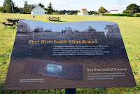
Fort Humboldt State Historic Park is the site of the fort that was occupied from 1853 to 1870. The fort was built overlooking
We visited the park in early June and the weather was still very cool compared to the Central Valley of California where we had just come from. Being the "morning people" that we are, we arrived just before they opened the gate. Actually, it's a good thing we had Google Maps giving us the step-by-step directions, as the signage directing you to the site was not obvious. The gates opened at eight o'clock. The visitors center and the two buildings of the fort that remain were not scheduled to open until nine. We spent an hour and a half walking around the park, starting with a display of logging machinery that is co-located with the fort. The park is certainly well tended, but not well visited by all appearances. We pretty much had the park to ourselves with the exception of a local walking her dog and some high school kids on bicycles that I'm pretty sure were ditching the last day or two of school.
The buildings at the fort are the original hospital and a reconstructed surgeon's quarters. The hospital building has some displays on the history of the fort, but unfortunately they were not open during the time we were there. I guess that the park is staffed by volunteers and they were having a late morning. It was disappointing, but the main thing to see when you visit a historic site is actually the location and the lay of the land. The fort is on a bluff and today the city of Eureka has grown around the bay that the fort overlooks. It is obvious that the fort is defensible with a small number of soldiers (I believe that less than 50 were typically at the fort), and the view allows for easily spotting arriving ships.
Probably the best part of visiting Fort Humboldt State Historic Park is knowing that you are walking on the same ground as U.S. Grant, George Crook, and other noteworthy soldiers from the Civil War period. You also gain a glimpse into what their living conditions were while serving in what was then still a far off place, well removed from the civilization in the East that these soldiers were used to.
Next stop in this little "Grant Pilgrimage" I've got going on will be
a visit to Fort Vancouver, another frontier outpost where Grant served before his civilian hiatus from the army.
NARA's Prologue To End Print Version
Point Reyes and Drake's Bay
 |
| It is 308 steps down to the lighthouse, and 308 back up! |
So what does this trip have to do with history? Well, it's not about the lighthouse, although I do love them. If you look at a map of Point Reyes (Google Maps will do), you will see that the point wraps around a body of water named "Drakes Bay." Remember the story of Sir Francis Drake from elementary school? From 1577 to 1580, Drake and his ship, the Golden Hind, sailed into the Pacific to raid Spanish shipping, with the full
 |
| Waysides at the visitor center tell the story of Drake's stay in California. |
 |
| The cliffs along this bay supposedly reminded the English sailors of home. |
 |
| The only visitors to the beach on the day we visited were some elephant seals. |


