Showing posts with label Civil War. Show all posts

Veterans Visit National Parks for Free (and some Antietam pictures)

We visited the Antietam National Battlefield in Maryland and learned that veterans get access to National Parks and other Federal Public Lands for free. Forever.

Last week (September 17th) was the 161st anniversary of the Battle of Antietam. We have visited many times. Antietam, located next to the small town of Sharpsburg, Maryland, is my favorite Civil War battlefield. Antietam has historical significance in that the battle has a combined casualty count of 22,727 killed, wounded, and missing. That makes Antietam (or Sharpsburg to the Confederates) the highest one-day casualty count in American military history. It was the impetus for Abraham Lincoln’s Emancipation Proclamation, which changed the Federal cause for fighting the war from preserving the Union to ending slavery. Moreover, it is an easy battlefield to view the terrain and understand the flow of the battle. Climb the observation tower. It’s worth it. And finally, the battlefield park is more than a park or a tourist attraction. It’s hallowed ground where thousands of Americans fought and died. That being said, Antietam is also a beautiful place to go for a walk and enjoy the fall weather.

I was going to talk about the battle and the remodel of the Visitor Center. Also, I wanted to point out how cool it is to visit a battlefield as near to its anniversary as possible. That way you have good odds of similar weather and you get an idea of what the foliage looked like at the time of the battle. Instead, I wanted to make sure that you are aware of the new program that allows free access to active military, veterans, and Gold Star family members.

It was time to renew my annual National Park Pass. I was thinking that I’d score on that senior discount this year (one of the few advantages of getting old). When we walked up to the counter and told the Ranger on duty what we wanted, he asked if I was a veteran. I am, I said, and so is my wife. He then went on to explain that since last November, the National Park Service has been providing free lifetime access to NPS and other Federal lands to active military, veterans, and Gold Star families. Would I like an “America the Beautiful” lifetime pass for free? Yes, please.

Here are the official rules. To get your pass you need a Veteran ID. You can obtain a digital Veteran ID from the VA’s website. (When they started producing those, I had no idea. I’ve obviously been asleep at the wheel on these things over the years.) The NPS is not supposed to accept your DD214 as proof of your veteran status. They need to see your Veteran ID. To obtain the Veteran ID you can use a copy of your DD214. Sound bureaucratic? Hey, it’s the government, and if you are a veteran then this Catch-22 logic should make you feel right at home. But it’s worth the trouble. If you have your Veteran ID, then not only can you use it to get a lifetime pass to National Parks, but there are a bunch of other perks and discounts out there for veterans (like the ten percent discount at Cabela’s). So get your Veteran ID from the VA website (links below), then go in person to any NPS site and pick up your lifetime pass.

Enjoy some pictures of the battlefield from our trip last Wednesday. If you are looking for background on the Battle of Antietam, I have “Landscape Turned Red: The Battle of Antietam” by Stephen Sears on my shelf. Get out and enjoy a historic site while the weather is nice. Maybe I’ll see you at Valley Forge next week. 😉

Link: Information on National Park Passes

Link: VA website to obtain a Veteran ID

Mary Hays, AKA: Molly Pitcher

The Molly Pitcher Monument
Last week I posted about Hannah Duston and her escape from the Indians. Another monument to a strong female historical figure is the Molly Pitcher grave and statue in the Old Public Graveyard in Carlisle, Pennsylvania. Molly Pitcher is one of those stories that can be filed under the heading of “If it ain’t true it outta be.” Of course, that’s my Texas heritage coming out. But I’m convinced that there really is only one Molly Pitcher, her real name was Mary Hays, and she’s buried in Carlisle.

Here's her story: During the American Revolution, Mary Hays followed her husband, William Hays, to war, as a large number of women did. In those days, women would follow the army to care for their soldier family members in a variety of ways, like cooking, sewing, laundry, or assisting with medical care. One other task these volunteers provided was bringing water to the soldiers during training, or even during battle. These women earned the nickname “Molly Pitcher.” Molly is a way of saying Mary, and Pitcher of course is for the pitcher of water they’d carry.

The current monument is from 1916.
William Hays enlisted in Proctor’s 4th Pennsylvania Artillery in 1777. Mary first went with the battery to Valley Forge, then the next year to the Battle of Monmouth Courthouse in New Jersey. This is not disputed. During the battle, Mary was bringing water to the artillerymen in her husband’s battery. When her husband fell, either from a wound or heatstroke, Mary took over his job, using a ramrod to swab and load the canon.

Legend has it that during the battle she was seen working with the gun’s crew by General George Washington. The General supposedly congratulated her and made her a sergeant as a reward for her bravery. None of that can be proven, although Mary reportedly went by the nickname “Sergeant Molly” for the rest of her life. However, in 1830 a war veteran’s narrative was published that described the incident of a woman taking over for her husband on an artillery piece during the Battle of Monmouth. In it, the writer says that a British cannon ball passed between the woman’s legs, tearing through her skirt but leaving her unharmed.

After the battle, Mary Hays and her husband returned to their home in Carlisle, Pennsylvania. William Hays died in 1786. Mary later married again, to a man named John McCauley. In 1822, Mary was granted a pension by the state of Pennsylvania for her service. Mary died in 1832 and is buried in the Old Public Graveyard as Mary McCauley. The current Molly Pitcher monument was erected in 1916.

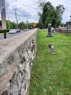
Union troops were behind this wall
during a Civil War skirmish.
There are a number of Molly Pitcher monuments. Some are in the form of street names, murals, and even business names. I believe that Molly Pitcher is a moniker given to women who followed their husbands to war during the Revolution. Mary Hays is the personification of that. Much like Rosie the Riveter was a name for women working in the defense industry during WWII and Naomi Parker was the inspiration for that. However, there is still controversy. You can read a Wikipedia article that does not question the existence of Molly Pitcher. An article on the American Battlefield Trust website, says that she is a composite character, made up of the many Molly Pitchers. Yet finally, there is an article from Smithsonian that says she probably never existed.

If you ever get the chance to walk around Carlisle, please do. Lots of history there from the Revolution to the Civil War. Take a look at the Old Public Graveyard on South Street at Bedford. It’s an interesting place, with the oldest burial from 1757. The east wall protected approximately 200 Union soldiers when Jeb Stuart’s Confederate cavalry raided Carlisle during the Gettysburg Campaign. They traded shots with Confederate skirmishers who were deployed in what would become Letort Park, on the other side of the creek. But that’s a story for a future post. 

Fort Point National Historic Site, San Francisco

The Civil War-Era Fort under the Golden Gate Bridge

Did you know that there was a Civil War-era fort under the Golden Gate Bridge? I realize that at times I can be slow on the uptake, but I didn’t know about Fort Point until just a few years ago. And I grew up in California! How could I not notice? I’ve driven over the bridge several times in my life. The first time way back in high school. When I was in the army, I even flew a helicopter from Camp Roberts to the Presidio in San Francisco – didn’t notice it then. Finally, Fort Point came on the radar several years ago when I visited the Presidio as a tourist. Who knew? 

The history of the site goes back to the late 1700s. The Spanish were worried about encroachment into California by Russia and Great Britain. They built a fort on a cliff at the southern point of the narrowest entry to the bay. That would later be known as the “Golden Gate.” The fort, Castillo de San Joaquin, was completed in 1794, was made of adobe walls, and mounted from 9 to 13 cannons. When Mexico gained independence from Spain, the Mexican army moved to Sonoma and let the fort deteriorate.

At some point during the Spanish and Mexican eras, the cliff that the fort was located on was known as the Punta del Cantil Blanco (point of the white cliff) became known as Punta del Castillo (Castle Point). After the Mexican-American war and the United States gained control of California in 1848, the name was carried over as “Fort Point.” Soon the Gold Rush was in full swing, California became a state in 1850, and the United States now needed to protect the bay. A series of defensive fortifications were proposed that included Alcatraz Island, Fort Mason (located adjacent to Fisherman’s Wharf), and Fort Point.

The construction on Fort Point began in 1853. The first task was to knock down the cliff and build the fort near sea level. The idea was that guns placed in the first level of the fort could skip cannonballs along the ocean and hit ships at the waterline. Two hundred former gold miners were employed on the construction of the fort for eight years, finishing it in time to be garrisoned just before the start of the American Civil War in 1861. The fort is constructed with seven-foot-thick walls and three levels, or tiers, that built with a reinforcing arch. The fort could aim 126 guns at any ship passing through the narrow Golden Gate, although during the Civil War there were only 55.

Fort Point never fired a shot in anger. Time and technology made the fort obsolete. Navies of the world moved on to ships made of iron and steel. By the 1890s the smoothbore cannons at Fort Point were scrapped in favor of rifled, larger, coast artillery emplaced in concrete batteries at Fort Winfield Scott on the west side of the Presidio. Fort Point was used as a barracks for a time until it fell into disrepair. Recommendations to have the fort demolished in the 1920s were turned down. The fort was left standing even as the Golden Gate Bridge was built over it in the 1930s. After World War II, efforts were made to preserve the fort. In October of 1970, President Nixon declared Fort Point a National Historic Site.

Read complete histories of Fort Point at the National Park Service website, the Presidio San Francisco website, or on Wikipedia.

Fort Point is well worth the trip alone. But certainly, be sure to put it on your itinerary when you plan a trip to San Francisco. I enjoyed it more than exploring the coastal artillery batteries at the Presidio. Those coastal defenses built in the early twentieth century are common. I’ve also visited them at the mouth of the Columbia River and protecting the entrance to the Puget Sound. But on the west coast, Fort Point is the only one of its kind. There are no other Civil War-era forts, well preserved, on the west coast. I was fascinated by the architecture of the fort and the technology for the time that it was built. During the summer months there might be living historians or reenactor groups at the fort. Check with the NPS website. Oh, and bring a jacket. You know the old joke: “The coldest winter I ever spent was a summer in San Francisco.” 😎

News Item: Relics Found in Gettysburg! (and a new museum soon)

Did you really think that we know everything there is to know about the battle of Gettysburg, or have discovered every relic or manuscript with a link to the famous Civil War battle?  No, of course you didn’t.  The Hanover Evening Sun reports that construction workers found a treasure trove of artifacts while working on a remodeling project on a dormitory at the Lutheran Theological Seminary in Gettysburg.

The building, known as the “Old Dorm” is undergoing a 15-month remodel that will turn it into an interpretive museum.  The building had been used as a hospital during the battle.  Tucked into the walls were old worn out shoes from the 19th Century.  It was believed that putting old shoes between wall joists would bring luck.  In the ceiling, believed to have fallen through the cracks in the floor above, were several letters belonging to civil war soldiers.  Several bottles were also found.

The work is being funded with a $4 million grant from the State of Pennsylvania.  When the project is completed, visitors will be able to have access to the cupola, where Union General John Buford surveyed the opening moves of the battle, as portrayed by Sam Elliot in the movie, Gettysburg.

The “High Water Mark” of the Confederacy

The phrase “high water mark of the Confederacy” is traditionally applied to Pickett’s Charge at the Battle of Gettysburg. It’s meaning is that before the assault there was hope for a Confederate victory and after the charge was repulsed the “tide had been turned” and the South was rolled back like the tides to their eventual capitulation. However, if we look at the Confederate invasion of Pennsylvania from strictly a geographical perspective, then the “high water mark” would have to be the farthest penetration north by Confederate military forces. That point just happens to be very near my home in Mechanicsburg – Camp Hill area of Cumberland County. So, after procrastinating for some months I finally got out early on a Sunday morning to go see how these locations are remembered. For a complete history of Civil War events in Cumberland County, visit www.cumberlandcivilwar.com.


During the Gettysburg Campaign in the summer of 1863, Confederate General Richard Ewell moved his corps north from Chambersburg through the Cumberland Valley lead by General Albert Jenkin’s cavalry brigade.   Faced with overwhelming odds, the Union forces in Carlisle withdrew to defend the approaches to Harrisburg.  On June 28, 1863, Mechanicsburg, about ten mile east of Carlisle, was the northernmost town to surrender to Confederate forces.  The Rupp House, just outside of Mechanicsburg at the time, was occupied as headquarters for General Jenkins.  A monument commemorating Jenkins and his Confederate cavalry is now located at the location (an office building at 5115 Trindle Road in Mechanicsburg).

Union forces set up defenses on the west side of the Susquehanna to protect the approaches to Harrisburg, about five miles northeast of Mechanicsburg.  Under the command of Major General Darius Couch built two earthwork forts on Washington Heights (then known as Hummel’s Heights) in today’s community of Lemoyne, overlooking Harrisburg across the Susquehanna River.  Fort Washington was the main fortification was located in an area around Cumberland Road between Walnut and Indiana Avenues.  (I found no commemoration of the fort, but it’s a nice neighborhood.)  A few blocks west was built a smaller, forward position that was dubbed Fort Couch.  Honoring Fort Couch is a large monument and remains of the earthworks set aside in a small park at 8th Street and Indiana Avenue.  This park is surrounded by residences on all sides and there is no dedicated parking.  Unfortunately with the urban growth you can’t see the approach that General Couch would have seen, but you can certainly appreciate the military significance of the positions on Hummel’s Heights.

Pennsylvania State Historic Markers commemorating the northernmost skirmishes are a little harder to spot if you are whizzing by in your car.  Two small engagements took place between Mechanicsburg and Lemoyne.  On June 28, General Jenkins sent a small force to engage Union militia units that fled Mechanicsburg as the Confederates entered the town.  The Union troops set up a battery of artillery and a hasty defense at Oyster Point, a tavern located on Market at 31st Street in Camp Hill.  The Confederates returned the next day with a larger force, but could not dislodge the Yankees.  The engagement at Oyster Point was probably a diversion to cover Jenkins reconnaissance of the river crossings to Harrisburg from Slate Hill in New Cumberland.  The state marker was hard to spot.  It was a foggy morning and the sign was hidden behind some trees.  I’ve probably driven past it at least eight times without ever noticing it before.

On June 30th two New York militia regiments supported by a battery of Pennsylvania artillery engaged two Virginia cavalry regiments around the McCormick farmhouse, just north of Mechanicsburg along the Carlisle Pike.  This engagement became known as the skirmish at Sporting Hill.  There is a state marker at the corner of Sporting Hill Road and the Carlisle Pike.  It’s a busy intersection, but you can pull into the parking lot of the “Ye Old Ale House” and walk out to the corner to read the marker.  Sporting Hill was the northernmost engagement in the Gettysburg Campaign, and as such can be called the high water mark of the Confederacy.  In fact, Pennsylvania historian Robert Grant dubbed it so in his article “Highwater 1863: The Confederate Approach to Harrisburg” in Pennsylvania History, 1963 (placed online courtesy of ExplorePAHistory.com).

Sporting Hill can be considered a Union victory, in that the Confederates left the field.  But in all fairness, their hurried departure was due to Ewell’s orders to move his corps to Gettysburg, the famous battle kicking off the next day.  The Cumberland County Visitors Bureau has produced an excellent self-guided tour brochure/map for “The Civil War on the West Shore.”  It is available in pdf for download.  Get the full feel of the Gettysburg Campaign by taking this tour.  It’s worth it. 

Visiting Monocacy National Battlefield

The season for tramping around battlefields is quickly drawing to a close. A couple of weeks ago Sheila, Meaghan, and I went to Monocacy National Battlefield near Frederick, Maryland. If you have never heard of the battle or visited Monocacy, don’t feel too bad. It is not one of the better known Civil War battles or National Parks. I would definitely recommend spending an afternoon at Monocacy, but not as your only experience in studying Civil War sites. Your one-stop, of course, is Gettysburg. However, I would highly recommend Antietam as well. (Which I just realized I’ve never talked about and it’s only 20 minutes away from my house. I promise I will rectify that soon.) Nevertheless, there are other reasons to visit Monocacy.

For a thorough discussion of the battle at Monocacy, see the NPS website. I’ll give you the gist of it here. In the early summer of 1864, Confederate Lieutenant General Jubal Early and an army of approximately 15,000 crossed into Maryland near Sharpsburg. This would constitute the confederates third invasion of the North. When Early passed Harpers Ferry on July 4, 1864, personnel with the B&O railroad there alerted the Union army. Early’s mission was to draw Union forces arrayed against Robert E. Lee away from Petersburg, Virginia, by threatening the little defended Washington, D.C.

Union Major General Lew Wallace commanded the “Middle Department” that included Washington, Baltimore, Frederick, and Harpers Ferry, etc. Upon hearing of the threat posed to Washington or Baltimore by Jubal Early’s army, put together a force that would eventually number close to 6,000. Wallace rushed his force to Monocacy Junction on the B&O Railroad, just southeast of Frederick, Maryland. In this area the B&O Railroad, the Georgetown Pike (present day Hwy 355), and the National Road to Baltimore (present day Hwy 40) all crossed the Monocacy River. It was the most likely place to delay the rebels until reinforcements arrived.

On the morning of July 9, 1864, Confederate forces moved forward out of Frederick and began to engage Union forces. Although outnumbered three-to-one, the Federals under Lew Wallace successfully blocked Early’s confederates in the daylong battle. By nightfall, the Union had withdrawn from the field and sustained casualties of approximately 1,300 men dead, wounded or captured.

While considered a Confederate victory, as Early’s men continued to hold the field, the rebels were delayed for an entire day and sustained casualties of approximately 900 killed, wounded, or captured. The delay gave the Union time to reinforce Fort Stevens in the District of Columbia, which Early moved forward and attacked two days later. The Confederates fired on Fort Stevens, but Early knew that now that Union reinforcements had arrived, he did not have the resources to take the fort and threaten Washington further. Early withdrew the next day, July 12th, and headed back to Virginia.

Today, Monocacy National Battlefield has a modern visitor’s center/museum/gift shop and a 5-stop auto tour. It’s a relatively small affair, but it is certainly worth an afternoon of your time. At each auto stop there is a walking trail. Therefore, you can either just look around and read the waysides, or have a pleasant walk of a few hundred yards or up to a mile and a half. This ground on which the Civil War was fought also has a history that dates from colonial times. For example, the walking path at the Thomas Farm, auto stop number four, goes by the site of the Middle Ferry over the Monocacy River. This ferry site dates from before the French and Indian War. The Best Farm, stop number one on the auto tour, was formerly l’ Hermitage, a plantation established in 1794 that at one point kept up to 90 enslaved African Americans. The NPS has done an archeological dig on the site and information can be found on the website.

And speaking of the website, make sure you visit the NPS’ Monocacy National Battlefield website before you go, or especially if you can’t visit the park in person. This is an excellent site for their historical articles and multimedia downloads. On the website, you can download MP3 files for an audio tour while you are driving the auto tour. The NPS has even created some virtual tour videos of different points on the battlefield. The website is worth a look. Monocacy is worth a visit.

Trippin' through Gettysburg

The Fourth of July holiday weekend is right around the corner. I’m such a military history geek, that thinking about the Fourth always reminds me of the anniversary of the Civil War battle of Gettysburg (July 1-3, 1863). This is the perfect time to tell you about my visit to the Battlefield while I was on my research trip in May.

As I’ve mentioned before in this blog, my friend John works as a park ranger at Gettysburg National Military Park and rents a house on the battlefield from the NPS. Of course I wanted to visit my friend that I hadn’t seen in three years, but I was also looking forward to another visit to one of my favorite Civil War battlefields and getting a personal tour from the most knowledgeable person I know about the battle and the war.

I had visited Gettysburg on several occasions over the years since my first visit back in 1988. However, this was the first time I had toured the Battlefield and the town with a guide. Even for those of you who are familiar with the battle (as I thought I was), I highly recommend touring the battlefield with a licensed guide or attending one of the presentations given by the NPS staff. John was able to show me, on the ground, parts of the battle that have gotten little attention from both historians and popular culture. I won’t go into the history of the battle, but leave you with the guidance that there is much more to the battle than what is portrayed in the movie Gettysburg. The more you learn about it the more you want to know.

I invoke the Hollywood version of the battle (one of my favorites mind you), because during our tour John pointed out several items that the movie got wrong. He also gave me the background on a few of the monuments that over the decades since the battle have been placed for politics and tourism as well as honoring the sacrifices of our soldiers. Actually, the history of the battlefield as “hallowed ground” versus “tourist attraction” is as fascinating for me as the battle itself. For example, the term “high-water mark of the Confederacy” applied to Gettysburg, and specifically Pickett’s Charge, was coined by a tourism promoter years after the battle. If we are speaking in terms of Confederate military strength, one could argue that there are other points during the war when things looked much worse for the Union. In terms of geography, organized Confederate forces fought in the same campaign about 35 miles north of Gettysburg near Camp Hill, Pennsylvania, in what is known as the Skirmish of Sporting Hill.

Since I had visited the area before, it is interesting to see what is changing and what stays the same. The park is conducting projects to restore the terrain to what it looked like during the battle. Read about it in the park newspaper. There have been some trees removed around the Devil’s Den since my last visit. There are now some new peach trees in the Peach Orchard. The NPS has acquired a new “witness” house on the Emmitsburg Road, and the new Visitor Center opened in 2008 (which is fantastic!). Some things never change: the debate is raging in town about a proposed casino and hotel on US 15. That was voted down the last time I was there back in 2006. The casino promoters are back for another attempt at a permit.

Therefore, this trip to Gettysburg brought up several of those internal debates I have with myself. The primary being: At what level should we teach, or expect the public to know, history? Moreover, is a little drama such a bad thing if we can engage the public to tune in to the lessons of history? How far should we go to protect our historic sites? Does a place like Gettysburg deserve protection from what is built nearby? The analysis of these questions, whether I discuss and debate them with others or just in my head, is what excites me about public history.

I’ll close by saying, "Thanks again, John!" for the fantastic tour and a great steak dinner.