Oral Histories and Remembering the Forgotten War

 A reminder to talk to your relatives now.

It's great to get reader feedback. Over the years I have heard from several folks who read The Boldest Plan is Best who told me that their father or grandfather had served with the 509th Parachute Infantry Battalion during WWII. Unfortunately, they also shared that their relative passed away without telling them about their experiences.

Way back in 2008, I wrote a post about the National Day of Listening, sponsored by StoryCorps. I shared then about doing an "oral history" session with my own dad about his service with the 187th Airborne RCT in Korea. It wasn't easy to get him to open up about it. He never talked about combat when I was growing up. A familiar story, I know. But I worked at it. I made it kind of a formal thing and recorded our conversations. That seemed to work to a certain extent. Having served myself might have helped. But I encourage you to do whatever it takes to get the veterans talking.

Here's an article I wrote based on those talks I had with my dad a few years before he passed away. It was the first thing I ever wrote and got it printed in the reader submission part of the old History Channel Magazine. I hope you enjoy it.

Remembering the Forgotten War

Corporal Bob Broumley, Kumwha Korea, 1953
Most of us who enjoy history have heard the cliché that the Korean Conflict is known as the "Forgotten War." However, clichés are often based on truth and this instance is certainly a prime example.

Most Americans do not know about the intensity of that conflict, its importance as the first "limited war," or its significance as part of our overall Cold War victory over communism. Although termed a police action, Korea was not a trivial event; from 1950 to 1953, approximately 1.79 million uniformed service members went into that theater of operations; 36,574 died and another 103,284 were wounded. And according to the U.S. Department of Veterans Affairs, we lost more than 173,000 Korean War veterans in 2007.

One of these Korean War veterans is Bob Broumley from Fort Worth, Texas. When the North Koreans crossed the Thirty-eighth Parallel to invade South Korea on June 25, 1950, Bob was enjoying the summer before his senior year at Tech High School. He would not wait to be drafted and joined the Army after high school. He took great pride in the fact that the two-letter identifier on his service number was "RA," which stood for "regular army" vs. "US" for draftees and "NG" for National Guard members.

Practice jump in Japan, 1952
Upon completion of infantry basic training at Fort Ord, California, and airborne school at Fort Benning, Georgia, 19-year-old Pvt. Bob Broumley shipped out to Korea. He, like most of the new soldiers on his troop transport, moved up as replacements in units that had heavy combat losses. Broumley's first assignment was as a rifleman with the 2/279th Infantry Regiment, 45th Infantry Division, which had been mobilized from the Oklahoma National Guard.

The 2/279th Raider Platoon was tasked with gathering intelligence that included raiding the enemy trench for prisoners. Although assigned to a rifle company as a BAR (Browning Automatic Rifle) man, Broumley accompanied the Raiders on one occasion. A section of the enemy trench between bunkers was selected. Automatic weapons fire would isolate that section from the bunkers on either end. An assault team would then go into the trench and kill or capture any enemy soldiers found there. Quick, violent, and dangerous, the operation was over in minutes.

Ceasefire Declared

After two trips to the line and a stint guarding prisoners of war on the infamous Koje-Do Island, Broumley transferred to the 187th Regimental Combat Team (Airborne) in September 1952. The 187 RCT was being refit in Japan as a theater reserve under the command of Brig. Gen. William Westmoreland. Broumley was ready for the challenge.

Sgt Bob Broumley, Fort Bragg, 1954
Through the winter and spring of 1953, the "one-eight-seven" trained hard in Japan. The days were filled with physical training, small-unit exercises, and practice jumps. The unit was always aware that they might be needed again in Korea. 

The stalemated war continued while both sides jockeyed for position in the armistice for which everyone was waiting. As those talks came close to an agreement, the Chinese Communist Forces threw a massive assault against the line, overwhelming South Korean forces. The 187 RCT was rushed to Korea once again to plug the gap, and Broumley (now a corporal) went with them. 

About a month later, on July 27, 1953, the armistice was signed. 

Broumley had enough "points" to rotate home shortly after the ceasefire. He served the remainder of his time at Fort Bragg, North Carolina, with the 82nd Airborne Division. Staff Sgt. Bob Broumley left the service in 1954 and returned to Fort Worth. He got his job back in the grocery store where he worked during high school.

The 1st Armored Division "Old Ironsides"

View the Index of Unit Histories


A Short History of the 1st Armored Division
"Old Ironsides"

The 1st Armored Division, nicknamed "Old Ironsides," is the oldest and most recognizable armor division in the United States Army. It was the first armored division to see combat in World War II. The Division is currently home-based at Fort Bliss, Texas, and is part of the US III Corps.

As part of the mechanization of the U.S. Army and the buildup for WWII, cavalry and reconnaissance units were brought together to form the 1st Armored Division at Fort Knox, Kentucky on July 15, 1940. Major General Bruce R. Magruder was the Division's first commander, serving in that capacity from July 1940 until March 1942. General Magruder is also responsible for the Division's famous nickname. In 1941, General George S. Patton Jr. had just named his 2nd Armored Division "Hell on Wheels." The 1st Armored Division needed a nickname too, so General Magruder held a contest to find a suitable name. Approximately two hundred names were submitted including "Fire and Brimstone" and "Kentucky Wonders." The General chose to study them over the weekend but none of the suggestions appealed to him. It happened that General Magruder had just bought a painting of the U.S.S. Constitution during a drive for funds for the preservation of that famous fighting ship, which is nicknamed "Old Ironsides." General Magruder was impressed with the parallel between the development of the tank and the Navy's "Old Ironsides" spirit of daring and durability. He decided the 1st Armored Division should also be named "Old Ironsides."

The 1st Armored Division boarded the Queen Mary at the New York Port of Embarkation, Brooklyn Army Terminal on May 11, 1942. Five days later the soldiers of the Division landed in Northern Ireland and trained on the moors. On October 29, 1942, Old Ironsides moved to England to depart for North Africa.

The 1st Armored Division's first contact with an enemy was as part of the Allied invasion of North Africa, Operation Torch on November 8, 1942. The Allies did receive unexpected, and heavy, resistance from Vichy-French units; however, the invasion forces suppressed all resistance in the beachhead area within three days. Old Ironsides then advanced toward Tunisia. The soldiers of the Division learned hard lessons about armored warfare and the harsh conditions of North Africa.

In January of 1943 Old Ironsides was part of II Corps and received the mission of defending central Tunisia against an Axis counterattack. In February the 1st Armored Division met with a superior German armored force at Kasserine Pass. The Division sustained heavy losses in personnel and equipment and was forced to withdraw. Old Ironsides was battered but kept in mind its lessons learned. The Germans outran their supply lines and faced determined Allied resistance. After three more months of hard fighting, the Allies could finally claim victory in North Africa. Old Ironsides was reorganized in French Morocco and then moved to Naples, Italy on October 28, 1943, to support the Allied effort there.

As part of General Mark Clark's U.S. Fifth Army, the 1st Armored Division took part in the attack on the infamous Winter Line in November of 1943. Old Ironsides then flanked the Axis forces in the landings at Anzio and moved on to participate in the liberation of Rome on June 4, 1944. The 1st Armored Division continued to serve in the Italian Campaign until German forces in Italy surrendered on May 2, 1945. In June of 1945, Old Ironsides was moved to Germany as part of the U.S. Army occupation forces.

In the drawdown of forces after WWII, the 1st Armored Division was deactivated on April 25, 1946. With the success of the Russian-made T-34 tank by the enemy at the outset of the Korean War in 1950, there was a renewed enthusiasm for armored forces in the U.S. Army. As part of the new buildup of forces, Old Ironsides was re-activated on March 7, 1951, at Fort Hood, Texas, and was the first U.S. Army unit to field the new M48 Patton tank.

Although the 1st Armored Division did not participate as a division in the Vietnam War, two of their subordinate units did. Company A, 501st Aviation and 1st Squadron, 1st Cavalry served with distinction. Both units earned Presidential Unit Citations and 1-1 Cavalry received two Valorous Unit Awards and three Vietnamese Crosses of Gallantry. Neither unit was officially detached from the 1st Armored Division. Veterans of both units may wear the Old Ironsides as a combat patch. Also, in 1967 three Old Ironsides infantry battalions were formed into the 198th Infantry Brigade and deployed to Vietnam. Two of those battalions, 1-6th Infantry and 1-52nd Infantry, were returned to the 1st Armored Division.

As Vietnam wound down, the United States turned its attention back to the Cold War in Europe. The 1st Armored Division was moved to Germany in 1971, home-based in the West German city of Ansbach. The Division remained in Germany for the next twenty years as part of the American forces committed to a NATO defense of Europe.

In November of 1990, Old Ironsides was alerted for deployment to the Middle East in response to the Iraqi invasion of Kuwait. In less than two months the Division moved 17,400 soldiers and 7.050 pieces of equipment by rail, sea, and air to Saudi Arabia in support of Operation Desert Shield. On February 24, 1991, the 1st Armored Division crossed into Iraq to begin Operation Desert Storm as the leading unit in VII Corps' main flanking attack. Its mission was to destroy the elite Iraqi Republican Guards Divisions. In an 89-hour blitz across the desert, Old Ironsides traveled through 250 kilometers of enemy territory. They destroyed 768 tanks, armored personnel carriers, and artillery pieces. The 1st Armored Division also captured 1,064 prisoners of war. Old Ironsides returned to Ansbach, Germany on May 8, 1991. Their triumph was celebrated by a visit from the Vice President of the United States and participation in victory parades in Washington D.C. and New York City.

The 1st Armored Division was called to serve once again, this time in the Balkans. Old Ironsides was ordered to Bosnia-Herzegovina and part of Operation Joint Endeavor on December 14, 1995. The 1st Armored Division was relieved by the 1st Infantry Division and returned to Germany in November of 1996.

In 1999, Old Ironsides was deployed again. This time 1st Armored Division was supporting Operations Allied Force and Joint Guardian. Operation Allied Force took Old Ironsides soldiers to Albania in response to the ethnic cleansing and fighting there. Operation Joint Guardian was to uphold the United Nations Security Council resolution to bring peace back to the Kosovo region.

The 1st Armored Division began its participation in the global war on terrorism when it received deployment orders to the U.S. Central Command on March 4, 2003. By April 15th Old Ironsides was moving out to participate in Operation Iraqi Freedom. During their 15-month deployment, Task Force 1st Armored Division was the largest division-based task force in U.S. Army history. Units serving with the Task Force included brigade-sized elements from the 82nd Airborne Division, the 3rd Infantry Division, the 1st Cavalry Division, the 2nd Armored Cavalry Regiment, the 124th Infantry Battalion, the 18th and 89th Military Police Brigades and the 168th MP Battalion. At its height, more than 39,000 soldiers were part of Task Force 1st Armored Division. The Division took responsibility for Baghdad in April of 2003. Old Ironsides was scheduled to return to Germany in April of 2004, but their tour was extended by three months to defeat a Shia militia led by Moqtada Al Sadr.

The Division's 3rd Brigade was deployed to Iraq once again for Operation Iraqi Freedom III in January of 2005, this after only eight months at home. They were attached to the 3rd Infantry Division as part of Task Force Baghdad. The 2nd Brigade Combat Team (BCT) deployed to Kuwait in November 2005 in support of Operation Iraqi Freedom IV. Old Ironsides' 1st Brigade deployed again to Iraq in January 2006.

In 2005, the Base Realignment and Closure (BRAC) commission determined that the 1st Armored Division should leave its home bases in Germany and move to Fort Bliss, Texas. While it took several years to accomplish the movement, Old Ironsides' division headquarters uncased its colors in May 2011.

Like their naval namesake, the 1st Armored Division carries with it the traditions and military values for which Old Ironsides has been known for over half a century. They also are the standing armor division of the United States Army, on the cutting edge of technology and tactics, and remain relentlessly strong today. Both active soldiers and veterans are proud to wear the 1st Armored Division patch and say, "I was with Old Ironsides."

View the Index of Unit Histories

Mary Hays, AKA: Molly Pitcher

The Molly Pitcher Monument
Last week I posted about Hannah Duston and her escape from the Indians. Another monument to a strong female historical figure is the Molly Pitcher grave and statue in the Old Public Graveyard in Carlisle, Pennsylvania. Molly Pitcher is one of those stories that can be filed under the heading of “If it ain’t true it outta be.” Of course, that’s my Texas heritage coming out. But I’m convinced that there really is only one Molly Pitcher, her real name was Mary Hays, and she’s buried in Carlisle.

Here's her story: During the American Revolution, Mary Hays followed her husband, William Hays, to war, as a large number of women did. In those days, women would follow the army to care for their soldier family members in a variety of ways, like cooking, sewing, laundry, or assisting with medical care. One other task these volunteers provided was bringing water to the soldiers during training, or even during battle. These women earned the nickname “Molly Pitcher.” Molly is a way of saying Mary, and Pitcher of course is for the pitcher of water they’d carry.

The current monument is from 1916.
William Hays enlisted in Proctor’s 4th Pennsylvania Artillery in 1777. Mary first went with the battery to Valley Forge, then the next year to the Battle of Monmouth Courthouse in New Jersey. This is not disputed. During the battle, Mary was bringing water to the artillerymen in her husband’s battery. When her husband fell, either from a wound or heatstroke, Mary took over his job, using a ramrod to swab and load the canon.

Legend has it that during the battle she was seen working with the gun’s crew by General George Washington. The General supposedly congratulated her and made her a sergeant as a reward for her bravery. None of that can be proven, although Mary reportedly went by the nickname “Sergeant Molly” for the rest of her life. However, in 1830 a war veteran’s narrative was published that described the incident of a woman taking over for her husband on an artillery piece during the Battle of Monmouth. In it, the writer says that a British cannon ball passed between the woman’s legs, tearing through her skirt but leaving her unharmed.

After the battle, Mary Hays and her husband returned to their home in Carlisle, Pennsylvania. William Hays died in 1786. Mary later married again, to a man named John McCauley. In 1822, Mary was granted a pension by the state of Pennsylvania for her service. Mary died in 1832 and is buried in the Old Public Graveyard as Mary McCauley. The current Molly Pitcher monument was erected in 1916.

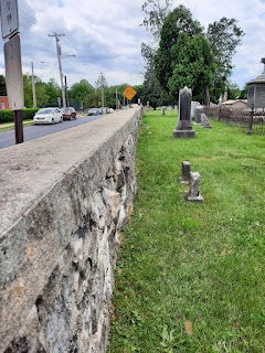
Union troops were behind this wall
during a Civil War skirmish.
There are a number of Molly Pitcher monuments. Some are in the form of street names, murals, and even business names. I believe that Molly Pitcher is a moniker given to women who followed their husbands to war during the Revolution. Mary Hays is the personification of that. Much like Rosie the Riveter was a name for women working in the defense industry during WWII and Naomi Parker was the inspiration for that. However, there is still controversy. You can read a Wikipedia article that does not question the existence of Molly Pitcher. An article on the American Battlefield Trust website, says that she is a composite character, made up of the many Molly Pitchers. Yet finally, there is an article from Smithsonian that says she probably never existed.

If you ever get the chance to walk around Carlisle, please do. Lots of history there from the Revolution to the Civil War. Take a look at the Old Public Graveyard on South Street at Bedford. It’s an interesting place, with the oldest burial from 1757. The east wall protected approximately 200 Union soldiers when Jeb Stuart’s Confederate cavalry raided Carlisle during the Gettysburg Campaign. They traded shots with Confederate skirmishers who were deployed in what would become Letort Park, on the other side of the creek. But that’s a story for a future post. 

Hannah Duston and Two Massacres

Hannah Duston's Capture and Escape from the Indians

The Hannah Duston statue is in
Haverhill, Massachusetts.
I did not make a special post for Women’s History Month last March. But I should have written about Hannah Duston (or sometimes it’s spelled Dustin). When I told my wife about Duston the first woman in the United States to have a statue erected in her honor - she said, “This woman sounds like a badass.” I’d have to agree with that, based simply on her story. But the memory of Hannah Duston is also an example of how we interpret our history through the years.

I really enjoy it when I catch myself in some preconceived notion. When you think of Puritan settlers in 1600s Massachusetts, do you think of a bunch of devoutly religious, passive people, kind of like the pilgrim mythology? Me too! Then while I was on the west coast, I read the story of Hannah Duston in the book “Massacre on the Merrimack: Hannah Duston's Captivity and Revenge in Colonial America” by Jay Atkinson. That book dissuaded me from my preconceptions and when we were recently passing through Massachusetts, I just had to take a look at the area where this story took place.

On the base of the statue you'll 
find a panel that shows Thomas
Duston defending his children.
First, here's the story in a nutshell:
Haverhill, Massachusetts, is on the north side of the Merrimack River, just 14 miles west of the Atlantic, or thirty-five miles north of Boston as the crow flies. Puritan settlers first arrived as early as 1640. Almost fifty years later, when our story takes place, it was still the edge of civilization, assuming the perspective of the English settlers. One of those settler families was the Dustons: Thomas and Hannah and their nine children.

During King William’s War (1688 – 1697), the governor of New France encouraged Native American tribes to raid English settlements. On March 15, 1697, Abenaki Indians from Quebec, made a raid on Haverhill. A “garrison house,” that was more heavily fortified (think brick, stone, or heavy logs) than your average farmhouse was on a hill above the Duston farm, but some distance away. As they had been instructed, eight of the Duston children headed that way when they heard the raid begin. Hannah, age 40 at the time, had given birth to her ninth child a couple of weeks earlier. She had a difficult birth and was still recovering. Present that morning was a neighbor/nurse, Mary Neff. Husband Thomas was working on building a brick garrison house of his own about half a mile away. When he heard the gunfire and whoops of Indians, he mounted his horse and headed for his house.

Another panel shows the killing
of the Indians.
When Thomas got to his house, he saw Indians heading across his fields. He knew that they would be able to catch his other children heading for the garrison house, so he grabbed his rifle and went to get between the Indians and his kids. Hannah, Mary, and the newborn were to sneak out a back door and make a run for it on their own. Thomas was successful in blocking the Indians who were after his kids. They withdrew when Thomas and the children made it to within rifle range of the three militiamen who were in the garrison house. Thomas borrowed a fresh horse and headed back with one of the militiamen to find his wife, but it was too late.

The Abenaki killed 27 colonists and took 14 captives, two of those were Hannah and Mary. The Indians took them on a speed march away from any potential pursuers. If any of the captives slowed them down, they were killed. Hannah’s newborn was stripped from her arms and killed in front of her. On the trail she and Mary received help in their survival from a fourteen-year-old boy named Samuel Lennardson who had been taken from Worcester, Massachusetts up to a year prior and had some modicum of trust from their captors.

The Duston Garrison House.
After weeks on the trail, other captives had all been killed or traded away. Hannah, Mary, and Samuel were left with a family group of two warriors, three adult women, and seven children. Along the trail Hannah had, along with the horrors she had witnessed, been told that her husband and children had all been killed and that when they arrived at their destination she would be tortured and either killed or sold into slavery. While camping on an island in the Merrimack River near present-day Boscawen, New Hampshire, the Indians let their guard down and all went to sleep. One version says that the warriors shared a bottle and passed out. Regardless, Hannah enlisted Mary and Samuel to participate. After the Indians went to sleep, they were able to get ahold of hatchets. Hannah and Samuel each killed one of the men while they slept. The three then proceeded to attack the women and children. Hannah left one of the children alive, a boy who had been kind to her on the trail. He subsequently fled. One of the women was severely wounded but also escaped. Hannah scalped the bodies in order to collect a bounty offered by the colony and to prove her story. The three captives made their escape in one of the Indian canoes, heading down the river to an English settlement.

The Aftermath
Hannah never wrote down her story, nor did Mary or Samuel. Hannah died in Haverhill sometime between 1736 and 1738. However, several people have written the story, claiming that they interviewed Hannah for the details. The most prominent of these was Cotton Mather. We know that she really did take the Indian’s scalps because her husband petitioned the government of the Massachusetts Colony to collect the bounty.

About a hundred years after Hannah’s death, her story was resurrected and she became a heroine. Some historians believe the story resonated with the public because of the Indian removal efforts that began in the 1820s. The first statue in her honor was erected in 1874 in Boscawen, New Hampshire (the site of her escape). The 35-foot statue depicts her with a hatchet in one hand and scalps in the other. In 1879 a statue of Hannah was placed in the GAR park in Haverhill. This one has Hannah holding a hatchet, but she’s pointing with the other hand as if to say, “You were bad.” On the sides of the base are depictions of the four events in her story: her capture, her husband’s defense of the children, killing her captors, and returning in a canoe. Today, some question why Hannah Duston was elevated to hero status, particularly considering that she killed six children along with the adults, like the tone of this article from Smithsonian. I’m afraid I don’t agree. You just can’t judge someone in those circumstances through the lens of our modern morality. And although it’s not right to say “they did it too” as an excuse, one source said that many of the settlers killed in the Abenaki raid were children. And what about Hannah's newborn?

By the way, the garrison house that Thomas was working on got finished. You can visit it, just outside of Haverhill. Like visiting a Civil War battlefield, when you’re stopping off at Dunkin’s and fighting the going to work traffic, it’s hard to visualize what it was like there in the 1600s. The Hannah Dustin statue and the Duston Garrison House help us remember. 

Changes to the C & O Canal NHP

Picture from 2011 post. You can
see the missing wall on the side
of the aqueduct. Click on the
picture to see a larger version.
We revisit the C & O Canal National Historical Park in Williamsport, Maryland.

After a ten-year stint on the west coast we’ve returned to the mid-Atlantic and the first thing we did was visit some of our old haunts and favorite historical sites. One of the first places we went to was the C & O Canal National Historical Park site in Williamsport, Maryland. I did a post on the canal towpath and the park back in 2011, as well as a post about the Paw Paw Tunnel, located up the canal about thirty miles. Give that first post a read to find out the history of the Chesapeake & Ohio Canal and what it is today. Here is a pretty good video that will also give you a rundown on the history of the canal.

An aqueduct is a bridge
for water.
Okay, if you didn’t go to those sources above, let’s review. Before roads and railroads, passengers and freight were moved by water. To conquer unnavigable rivers, canals were built that included aqueducts and locks to cross rough terrain and move boats through rises in elevation. These canal projects were a product of the industrial revolution and Europe got a big head start on the United States. Our most famous, the Erie Canal in New York state, opened in 1825 (you have the song stuck in your head now, don’t you?). The C & O Canal got a late start, not opening until 1850, navigating the Potomac River from Georgetown in Washington D.C. to Cumberland, Maryland. It continued to operate until the 1920s, so through the efforts of some dedicated individuals, we have a well-preserved example of these kinds of narrow boat canals AND a 184-mile recreational trail for biking and hiking.

Now there is water in the
aqueduct at Williamsport.
So what changed since I was in Williamsport a decade ago? First off, there is a new park headquarters building just up the hill from the visitors center and the turning pond. This makes sense to me, as Williamsport is just about midway between Cumberland and Georgetown. They have also restored the aqueduct over Conococheague Creek where it flows into the Potomac. That needs a little more explanation.

An aqueduct is built to carry water. In the case of the C & O, the aqueducts were built to carry boats over existing rivers. When I visited ten years ago, the aqueduct in Williamsport was missing a wall and visitors used it like a bridge to cross Conococheague Creek. The old canal had been filled in so you could walk from the visitors center around the turning pond and immediately be on the towpath. Now the aqueduct has been restored. The canal was dug out so that it connects to the turning pond, fills the aqueduct, and runs maybe forty yards beyond the north end of the aqueduct. This is a great improvement. My wife shared with me that before the improvement, she couldn’t visualize what the aqueduct did, since it looked like, and was used as, a bridge. Now that it has been repaired and has water in it, its function is clear.

That small portion of the
canal connects to the 
turning pond.
One more plug: I also think it’s a good place to put the park headquarters as Williamsport is (again in my humble opinion) the best place to visit the C & O if you only have a day to spend there. In Williamsport there is a turning pond, which you only find at the two ends of the path. There is a restored aqueduct with water. There is the elevated railroad bridge to see. Less than half a mile walk down the towpath is Lockhouse 44 with an excellent example of a canal lock. (If you need to know how one of these locks works, here’s a video I found that shows how one works, it’s from a canal in Great Britain, but I chose it to share with you because it looks very similar to the C & O.) And for a bonus, there is some Civil War history as well. Confederate forces crossed the Potomac here and in other locations along the canal during both campaigns in the north. Williamsport is an hour and a half drive from Washington D.C., less than an hour from Gettysburg, and only fifteen minutes from Antietam Battlefield. If you’re planning a trip in the area, consider adding this piece of history to your itinerary.

Less than a half mile walk down
the towpath is Lock #44.


A walkway on the elevated 
railroad bridge allows access to
the towpath.


There is a new park headquarters
up the hill, but the Visitors Center
is still in the barn by the pond.


The towpath trail is pet
friendly. Elvis the Corgi
approves. Please stay 
leashed and pick up. ;-)

The National Guard's Birthday: The First Muster

"The First Muster," a National Guard Heritage
Painting by Don Troiani, courtesy of the
National Guard Bureau.
For many Marines, the celebration of the Marine Corps Birthday is the social event of the year. The Corps was first established on November 10, 1775, by an act of the Second Continental Congress. That means this year the Marines will turn two hundred and forty-seven years old. The Navy beats them though, also established by an act of Congress on October 13, 1775, making that service just short of a month older. How about the Army you say? The United States Army claims June 14, 1775, as its birthday. On that date, the Continental Congress authorized the enlistment of expert riflemen to serve the United Colonies for one year. This was only two months after the Battle of Lexington and Concord, the event that kicked off the American Revolution.

However, the National Guard has them all beat by well over a hundred years. The roots of the modern National Guard are the colonial militias. The first formal militia was born on December 13, 1636, when the General Court of the Massachusetts Bay Colony ordered the organization of the Colony's militia companies into three regiments. The regiments were simply named the North, South, and East Regiments. Simple enough naming convention since the perceived threat was to the west, namely the Pequot tribe of Native Americans. All males between the ages of 16 and 60 were required to maintain arms and participate in the defense of the Colony. They drilled once a week and guards were posted in the event of an attack. The threat manifested itself in the Pequot War that took place from 1636 to 1638.

Although the order to organize the militia was given in December, the birthday of the National Guard is considered to be the date of the first unit to muster. You have to consider those New England winters, the colonists had to wait until the following spring to formally gather. The exact date has been lost, but we do know that the first regiment to muster was the East Regiment in Salem, Massachusetts. This year will mark the 385th year since that first muster, making the National Guard the oldest component of our military. On Saturday, April 9, 2022, a ceremony and reenactment will be held commemorating the event on Salem Common.

The Armed Forces Expeditionary Medal

 I don’t know how these things come up on my radar. But they do. I keep lists of things to look up and usually that just leads to more things to look up. Not complaining, but curiosity can be a harsh taskmaster.

(I thought) I knew that the Armed Forces Expeditionary Medal was awarded to all services for participation in military operations against enemy forces, like Grenada (Operation URGENT FURY) and Panama (Operation JUST CAUSE). It was for the short-term deployments that weren’t considered a war or a campaign. So I thought to myself, what other operations received the AFEM? Turns out, quite a few.

The medal was created by executive order in 1965 to recognize the deployment of military personnel to Southeast Asia (specifically think Vietnam) prior to that time. Over the years it has been authorized for twenty deployments around the world during the Cold War and after. By definition: “The Armed Forces Expeditionary Medal can be earned through U.S. military operations, operations in direct support of the United Nations and U.S. operations of assistance to friendly foreign nations.”

The list of operations begins with Lebanon, Vietnam, and the Taiwan Straits in 1958. It concludes with Operation JOINT GUARDIAN in Kosovo after 1 Jan 2014 and continues. In between are several deployments to Haiti, the Berlin Crisis, two deployments to the Congo. Stuff I wasn’t even familiar with. If you want to see the whole list, here’s a link to a pdf provided by the Department of Defense Personnel and Readiness website.

I’m glad I looked this up. It was a little exercise in reminding myself that everyone’s service is important. We should not forget the men and women who earned this service ribbon any more than we should fail to recognize the sacrifices of veterans of any declared war. And you can bet I'll be looking up some of the items on this list. ;-)

Defending Puget Sound: Fort Casey State Park

Spring finally sprung here in the Seattle area. We took an unusually nice day off weather-wise and drove to Fort Casey State Park on Whidbey Island, one of our favorite picnic spots. Along with Fort Worden and Fort Flagler state parks, Fort Casey is a former coast artillery position built around the turn of the twentieth century for the defense of Puget Sound. All three state parks are great for hiking, camping, or letting kids play on the old concrete batteries. Each one is around a two-and-a-half-hour drive from Seattle, including sometimes waiting for a ferry. But Fort Casey is my favorite.

A new coat of paint and a restored
"disappearing gun"
Fort Casey has always been less crowded than the more noteworthy Fort Worden. Fort Worden, located at Port Townsend was the shooting location for the movie “An Officer and a Gentleman” with Richard Gere. Also, Port Townsend is a picturesque tourist destination. Not that it’s a bad thing, but it brings with it crowds and there is a bit of litter and graffiti on the walls of the batteries. Fort Casey is quiet and clean. As a matter of fact, on our visit we saw that the park is being restored to its original condition in that workers are applying a fresh coat of paint and are mounting two restored “disappearing guns.” This work should be complete by the end of May.

During the second half of the nineteenth century the United States was concerned about the defense of their new territories in the Pacific Northwest, particularly Puget Sound. There was a sense of urgency that came with increased tensions with Spain in the lead-up to the Spanish-American war. A survey of Puget Sound by the Corps of Engineers easily noted that Admiralty Inlet was a narrow gateway into the rest of Puget Sound. In fact, Admiralty Inlet is only about four miles wide. Construction was started in the late 1890s on all three forts, Casey, Worden, and Flagler, that would create a “triangle of fire” for any invading fleet.

It is only 4 miles across Admiralty Inlet
between Forts Worden and Casey
Fort Casey was activated in 1901. By 1907 there were 34 pieces of coastal artillery sitting 100 feet above sea level. Similar strength was located at the other two points of the triangle. This investment in defense didn’t last very long. The threat of invasion diminished. So much so that during the First World War, 13 of the guns were removed from Fort Casey and sent to France as heavy artillery and rail guns. Battleships got bigger, matching the forts for the size of guns. Also, the advent of the airplane that was able to bomb the forts necessitated removing the cannons and replacing them with anti-aircraft guns during the Second World War. 

Great views at Fort Casey
After WWII, Fort Casey stood vacant and fell into disrepair. The fort was officially deactivated in 1953 and was later transferred to the Washington State Parks. If you would like to know more about the defenses of Puget Sound, read this article on HistoryLink.org, or visit the Coastal Artillery Museum at Fort Worden. You also might take a look at the book, "The Pictorial History of Fort Casey" by Terry Buchanan.


The Columbia River Maritime Museum

Learn About the Maritime History of the Pacific Northwest in Astoria, Oregon.

Astoria, Oregon, is located near the mouth of the Columbia River that creates the border between the states of Washington and Oregon. Astoria, the oldest city in Oregon, is an interesting and fun place to visit. Anyone who is on a Lewis and Clark pilgrimage is going to stay there of course. But there is a rich history about this town that goes way beyond the Corps of Discovery.

The Lewis and Clark Expedition spent the winter of 1805-06 at Fort Clatsop that they built just four miles to the southwest of modern-day Astoria. In 1811 fur trappers of the American Fur Company, owned by John Jacob Astor, established Fort Astoria where the city is today. Astoria is a deep-water port whose location on the Pacific coast made it a thriving resource town since then. Along with the fur industry, there is the timber industry and fish canneries for processing locally caught salmon. As you can imagine, not only the shipping of these commodities but the fishing industry as well creates a strong maritime history in Astoria. Oh, yes, and do not forget the Columbia bar.

Those of you not familiar with the area might be asking what the Columbia bar is exactly. Well, as the Columbia flows over 1200 miles all the way from Canada to the Pacific, it picks up sediment, as most rivers tend to do. As the waters of the Columbia hit the Pacific Ocean, it slows. When it does it drops the sediment creating what they call a “bar.” The Columbia Bar is an area about 3 miles wide and 6 miles long where the river enters the ocean. Because the bar creates shallows, the waters there tend to be rough and prone to a lot of unusual waves and currents. Plus, the sediment in the bar is always shifting around. That’s why large container ships need a river pilot to guide them into port. Moreover, combine the dangers of the bar with the naturally crappy weather of the Pacific Northwest and you’ve got some challenges. There are so many shipwrecks historically around this area (over 2,000 since 1792) that it has earned the nickname of the “Graveyard of the Pacific.”

This is where the Columbia River Maritime Museum comes in. This is a must-see when you visit Astoria. Most of the exhibits are indoors so don’t worry about the weather (oh, yeah, it rains a lot in Astoria). We made our trip pre-covid, but despite the pandemic, the museum is open with protocols. You will see exhibits on each of the industries that are a part of the history of this area. Particularly interesting to me is the information about the bar. Such a historically dangerous spot that had to be conquered (still true today) in order to exploit the resources of this region and on an individual level, earn a living. You’ll learn what a “bar pilot” does, and that there are only about 16 of these specialists working out of Astoria today. There is also a fine exhibit honoring the work of the United States Coast Guard in and around the Columbia River Bar.

When we visited Astoria, we stayed at the River Walk Inn, one of several hotels that provide a view of the marina from your room (nice!). From the hotel, you are able to catch a trolley that runs the length of the city with a stop at the Maritime Museum. The entry fee is a little pricey at $16 for adults, but that’s probably because I think all museums should be free. Regardless, the museum is worth it. Add it to your itinerary along with your pilgrimage to Fort Clatsop

For more information, visit the Columbia River Maritime Museum website.


Fort Point National Historic Site, San Francisco

The Civil War-Era Fort under the Golden Gate Bridge

Did you know that there was a Civil War-era fort under the Golden Gate Bridge? I realize that at times I can be slow on the uptake, but I didn’t know about Fort Point until just a few years ago. And I grew up in California! How could I not notice? I’ve driven over the bridge several times in my life. The first time way back in high school. When I was in the army, I even flew a helicopter from Camp Roberts to the Presidio in San Francisco – didn’t notice it then. Finally, Fort Point came on the radar several years ago when I visited the Presidio as a tourist. Who knew? 

The history of the site goes back to the late 1700s. The Spanish were worried about encroachment into California by Russia and Great Britain. They built a fort on a cliff at the southern point of the narrowest entry to the bay. That would later be known as the “Golden Gate.” The fort, Castillo de San Joaquin, was completed in 1794, was made of adobe walls, and mounted from 9 to 13 cannons. When Mexico gained independence from Spain, the Mexican army moved to Sonoma and let the fort deteriorate.

At some point during the Spanish and Mexican eras, the cliff that the fort was located on was known as the Punta del Cantil Blanco (point of the white cliff) became known as Punta del Castillo (Castle Point). After the Mexican-American war and the United States gained control of California in 1848, the name was carried over as “Fort Point.” Soon the Gold Rush was in full swing, California became a state in 1850, and the United States now needed to protect the bay. A series of defensive fortifications were proposed that included Alcatraz Island, Fort Mason (located adjacent to Fisherman’s Wharf), and Fort Point.

The construction on Fort Point began in 1853. The first task was to knock down the cliff and build the fort near sea level. The idea was that guns placed in the first level of the fort could skip cannonballs along the ocean and hit ships at the waterline. Two hundred former gold miners were employed on the construction of the fort for eight years, finishing it in time to be garrisoned just before the start of the American Civil War in 1861. The fort is constructed with seven-foot-thick walls and three levels, or tiers, that built with a reinforcing arch. The fort could aim 126 guns at any ship passing through the narrow Golden Gate, although during the Civil War there were only 55.

Fort Point never fired a shot in anger. Time and technology made the fort obsolete. Navies of the world moved on to ships made of iron and steel. By the 1890s the smoothbore cannons at Fort Point were scrapped in favor of rifled, larger, coast artillery emplaced in concrete batteries at Fort Winfield Scott on the west side of the Presidio. Fort Point was used as a barracks for a time until it fell into disrepair. Recommendations to have the fort demolished in the 1920s were turned down. The fort was left standing even as the Golden Gate Bridge was built over it in the 1930s. After World War II, efforts were made to preserve the fort. In October of 1970, President Nixon declared Fort Point a National Historic Site.

Read complete histories of Fort Point at the National Park Service website, the Presidio San Francisco website, or on Wikipedia.

Fort Point is well worth the trip alone. But certainly, be sure to put it on your itinerary when you plan a trip to San Francisco. I enjoyed it more than exploring the coastal artillery batteries at the Presidio. Those coastal defenses built in the early twentieth century are common. I’ve also visited them at the mouth of the Columbia River and protecting the entrance to the Puget Sound. But on the west coast, Fort Point is the only one of its kind. There are no other Civil War-era forts, well preserved, on the west coast. I was fascinated by the architecture of the fort and the technology for the time that it was built. During the summer months there might be living historians or reenactor groups at the fort. Check with the NPS website. Oh, and bring a jacket. You know the old joke: “The coldest winter I ever spent was a summer in San Francisco.” 😎

Angels Camp and the California Goldrush

I was going through a bunch of pictures on my computer today. I used to urge everyone to scan and organize old, printed photos. I finally got that chore done myself a while ago. But I have come to realize that my computer is a lot like an old shoebox full of photos tossed in. Time to get organized. I’m working on getting that chore done. While eating the elephant one bite at a time, I came across some pictures taken in the city museum of the California Gold Rush town of Angels Camp that I thought I’d share.

A short few years ago we did a California Gold Rush trip that included Old Town Sacramento, Sutter’s Fort, and the Marshall Gold Discovery State Park. Part of that trip was driving down a major portion of California State Highway 49, sometimes called the “Gold Rush Highway.” You can start northeast of Sacramento in the town of Grass Valley and drive the Gold Rush Highway over 200 miles south, all the way to Oakhurst and Yosemite National Park. Along the way, you’ll pass multiple Gold Rush Towns with intriguing names like Coloma, Sonora, Jamestown, Chinese Camp, Placerville, and of course, Angels Camp.

The California Gold Rush had an initial phase that featured placer mining. Basically a technique of finding gold on the surface that had washed down over the centuries from a “lode” or major vein up higher in the Sierra Nevada mountains. Placer mining relied on a constant supply of water. Moreover, water is typically what brings the gold down the mountain. So you’ll find Gold Rush towns in conjunction with streams and creeks. Angels Camp is no different.

Today the city of Angels Camp is located at the intersection of Hwy 49 and Hwy 4, about an hour’s drive east of the Central Valley city of Stockton. Back in 1848, the water running down the mountain at that site was known as Carson’s Creek. Shortly after the discovery of gold that year, there was an estimated 4,000 would-be miners trying their luck in the area (a funny coincidence because that’s about what the population of Angels Camp is today). A man named Henry Angell, having come out to California from Rhode Island, set up a store on the banks of Carson Creek. Soon the town that grew around the store took his name.

Mark Twain stayed in Angels Camp for a while. It was there that he was inspired to write “The Celebrated Jumping Frog of Calaveras County.” That story made Twain a household name. The story becoming an American classic, it then inspired the annual jumping frog contest held each year during May at the nearby Calaveras County fairgrounds. Get a full history of Angels Camp from the Historic Hwy 49 website

What I enjoyed most about Angels Camp was the Angels Camp Museum, which is managed by the city. They have a great collection of wagons and carriages, mining equipment, even a period printing press. You can even try your hand at panning for gold. It is family-friendly and well worth the stop. Although I’m sure covid protocols are in place, the website reports that the museum is open. Well, you might want to wait for summer. But plan a Gold Rush themed California vacation and put Angels Camp on the itinerary.